You are here: Home > Network List > TA - USArray Transportable Network (new EarthScope stations) Stations List
> Station D19K Kuna River, AK, USA > Earthquake Result Viewer
D19K Kuna River, AK, USA - Earthquake Result Viewer
| Earthquake location: |
Vanuatu Islands |
| Earthquake latitude/longitude: |
-16.1/168.1 |
| Earthquake time(UTC): |
2020/08/05 (218) 12:05:36 GMT |
| Earthquake Depth: |
175 km |
| Earthquake Magnitude: |
6.4 mww |
| Earthquake Catalog/Contributor: |
NEIC PDE/us |
|
| Network: |
TA USArray Transportable Network (new EarthScope stations) |
| Station: |
D19K Kuna River, AK, USA |
| Lat/Lon: |
68.49 N/158.12 W |
| Elevation: |
671 m |
|
| Distance: |
87.8 deg |
| Az: |
11.846 deg |
| Baz: |
212.354 deg |
| Ray Param: |
0.042650726 |
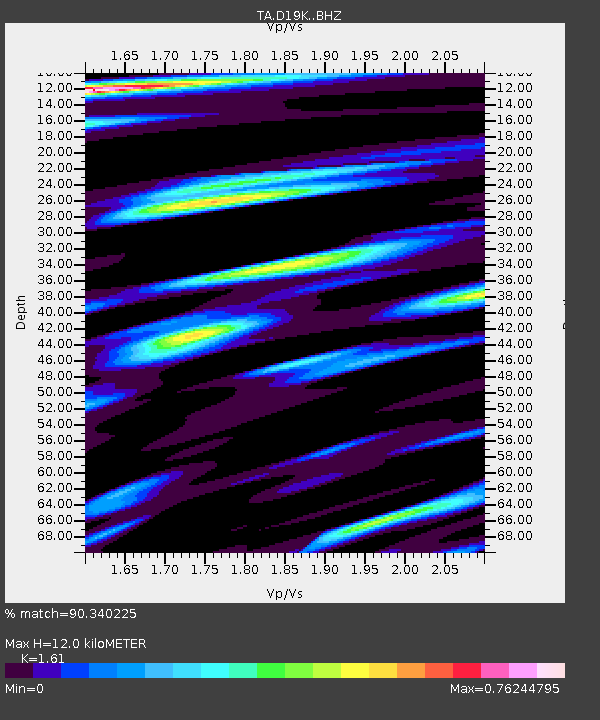
| Estimated Moho Depth: |
12.0 km |
| Estimated Crust Vp/Vs: |
1.61 |
| Assumed Crust Vp: |
6.221 km/s |
| Estimated Crust Vs: |
3.864 km/s |
| Estimated Crust Poisson's Ratio: |
0.19 |
|
| Radial Match: |
90.340225 % |
| Radial Bump: |
400 |
| Transverse Match: |
93.613266 % |
| Transverse Bump: |
400 |
| SOD ConfigId: |
21709731 |
| Insert Time: |
2020-08-19 12:22:54.830 +0000 |
| GWidth: |
2.5 |
| Max Bumps: |
400 |
| Tol: |
0.001 |
|

Signal To Noise
| Channel | StoN | STA | LTA |
| TA:D19K: :BHZ:20200805T12:17:34.399973Z | 32.545223 | 1.2920352E-6 | 3.969969E-8 |
| TA:D19K: :BHN:20200805T12:17:34.399973Z | 7.818926 | 3.6108895E-7 | 4.61814E-8 |
| TA:D19K: :BHE:20200805T12:17:34.399973Z | 3.8966331 | 1.6554695E-7 | 4.248461E-8 |
| Arrivals |
| Ps | 1.2 SECOND |
| PpPs | 4.9 SECOND |
| PsPs/PpSs | 6.1 SECOND |


