You are here: Home > Network List > TA - USArray Transportable Network (new EarthScope stations) Stations List
> Station D23K Nanushuk River, AK USA > Earthquake Result Viewer
D23K Nanushuk River, AK USA - Earthquake Result Viewer
| Earthquake location: |
Vanuatu Islands |
| Earthquake latitude/longitude: |
-16.1/168.1 |
| Earthquake time(UTC): |
2020/08/05 (218) 12:05:36 GMT |
| Earthquake Depth: |
175 km |
| Earthquake Magnitude: |
6.4 mww |
| Earthquake Catalog/Contributor: |
NEIC PDE/us |
|
| Network: |
TA USArray Transportable Network (new EarthScope stations) |
| Station: |
D23K Nanushuk River, AK USA |
| Lat/Lon: |
68.97 N/150.68 W |
| Elevation: |
406 m |
|
| Distance: |
89.8 deg |
| Az: |
13.768 deg |
| Baz: |
219.318 deg |
| Ray Param: |
0.041711703 |
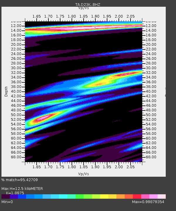
| Estimated Moho Depth: |
12.5 km |
| Estimated Crust Vp/Vs: |
1.90 |
| Assumed Crust Vp: |
6.221 km/s |
| Estimated Crust Vs: |
3.279 km/s |
| Estimated Crust Poisson's Ratio: |
0.31 |
|
| Radial Match: |
95.42709 % |
| Radial Bump: |
329 |
| Transverse Match: |
86.92113 % |
| Transverse Bump: |
393 |
| SOD ConfigId: |
21709731 |
| Insert Time: |
2020-08-19 12:22:57.999 +0000 |
| GWidth: |
2.5 |
| Max Bumps: |
400 |
| Tol: |
0.001 |
|
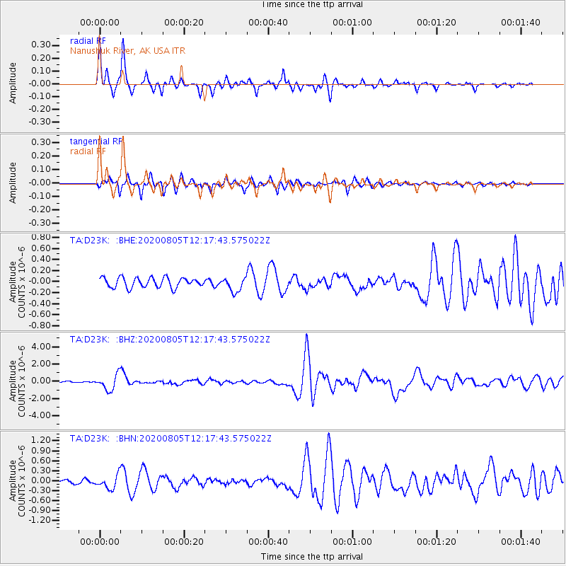
Signal To Noise
| Channel | StoN | STA | LTA |
| TA:D23K: :BHZ:20200805T12:17:43.575022Z | 10.282007 | 9.340897E-7 | 9.0847024E-8 |
| TA:D23K: :BHN:20200805T12:17:43.575022Z | 3.5732715 | 2.1287619E-7 | 5.957459E-8 |
| TA:D23K: :BHE:20200805T12:17:43.575022Z | 1.4822606 | 1.327115E-7 | 8.953318E-8 |
| Arrivals |
| Ps | 1.8 SECOND |
| PpPs | 5.7 SECOND |
| PsPs/PpSs | 7.6 SECOND |


