You are here: Home > Network List > TA - USArray Transportable Network (new EarthScope stations) Stations List
> Station E18K Tukpahlearik Creek, AK, USA > Earthquake Result Viewer
E18K Tukpahlearik Creek, AK, USA - Earthquake Result Viewer
| Earthquake location: |
Vanuatu Islands |
| Earthquake latitude/longitude: |
-16.1/168.1 |
| Earthquake time(UTC): |
2020/08/05 (218) 12:05:36 GMT |
| Earthquake Depth: |
175 km |
| Earthquake Magnitude: |
6.4 mww |
| Earthquake Catalog/Contributor: |
NEIC PDE/us |
|
| Network: |
TA USArray Transportable Network (new EarthScope stations) |
| Station: |
E18K Tukpahlearik Creek, AK, USA |
| Lat/Lon: |
67.42 N/160.60 W |
| Elevation: |
297 m |
|
| Distance: |
86.4 deg |
| Az: |
11.601 deg |
| Baz: |
210.038 deg |
| Ray Param: |
0.04367345 |
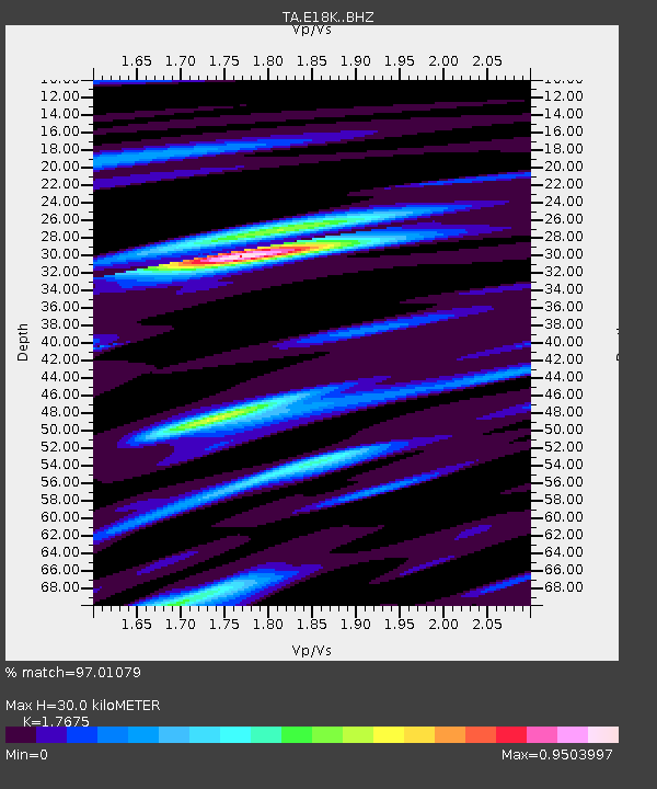
| Estimated Moho Depth: |
30.0 km |
| Estimated Crust Vp/Vs: |
1.77 |
| Assumed Crust Vp: |
6.276 km/s |
| Estimated Crust Vs: |
3.551 km/s |
| Estimated Crust Poisson's Ratio: |
0.26 |
|
| Radial Match: |
97.01079 % |
| Radial Bump: |
322 |
| Transverse Match: |
93.857574 % |
| Transverse Bump: |
400 |
| SOD ConfigId: |
21709731 |
| Insert Time: |
2020-08-19 12:23:06.112 +0000 |
| GWidth: |
2.5 |
| Max Bumps: |
400 |
| Tol: |
0.001 |
|
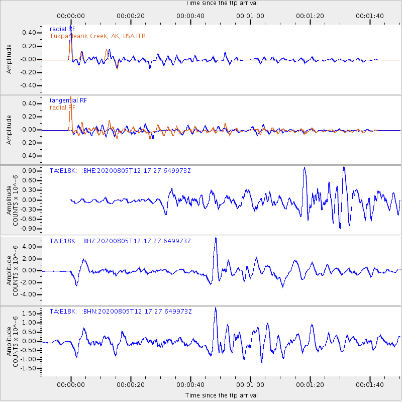
Signal To Noise
| Channel | StoN | STA | LTA |
| TA:E18K: :BHZ:20200805T12:17:27.649973Z | 19.348917 | 1.2700809E-6 | 6.564093E-8 |
| TA:E18K: :BHN:20200805T12:17:27.649973Z | 7.414255 | 4.3326162E-7 | 5.84363E-8 |
| TA:E18K: :BHE:20200805T12:17:27.649973Z | 5.452514 | 2.3120289E-7 | 4.2402988E-8 |
| Arrivals |
| Ps | 3.7 SECOND |
| PpPs | 13 SECOND |
| PsPs/PpSs | 17 SECOND |


