You are here: Home > Network List > TA - USArray Transportable Network (new EarthScope stations) Stations List
> Station G21K Allakaket, AK, USA > Earthquake Result Viewer
G21K Allakaket, AK, USA - Earthquake Result Viewer
| Earthquake location: |
Vanuatu Islands |
| Earthquake latitude/longitude: |
-16.1/168.1 |
| Earthquake time(UTC): |
2020/08/05 (218) 12:05:36 GMT |
| Earthquake Depth: |
175 km |
| Earthquake Magnitude: |
6.4 mww |
| Earthquake Catalog/Contributor: |
NEIC PDE/us |
|
| Network: |
TA USArray Transportable Network (new EarthScope stations) |
| Station: |
G21K Allakaket, AK, USA |
| Lat/Lon: |
66.52 N/153.51 W |
| Elevation: |
446 m |
|
| Distance: |
87.2 deg |
| Az: |
14.436 deg |
| Baz: |
216.723 deg |
| Ray Param: |
0.04311488 |
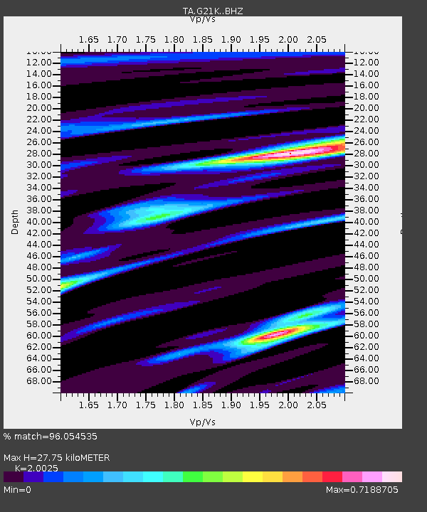
| Estimated Moho Depth: |
27.75 km |
| Estimated Crust Vp/Vs: |
2.00 |
| Assumed Crust Vp: |
6.455 km/s |
| Estimated Crust Vs: |
3.224 km/s |
| Estimated Crust Poisson's Ratio: |
0.33 |
|
| Radial Match: |
96.054535 % |
| Radial Bump: |
212 |
| Transverse Match: |
91.23444 % |
| Transverse Bump: |
297 |
| SOD ConfigId: |
21709731 |
| Insert Time: |
2020-08-19 12:23:50.590 +0000 |
| GWidth: |
2.5 |
| Max Bumps: |
400 |
| Tol: |
0.001 |
|
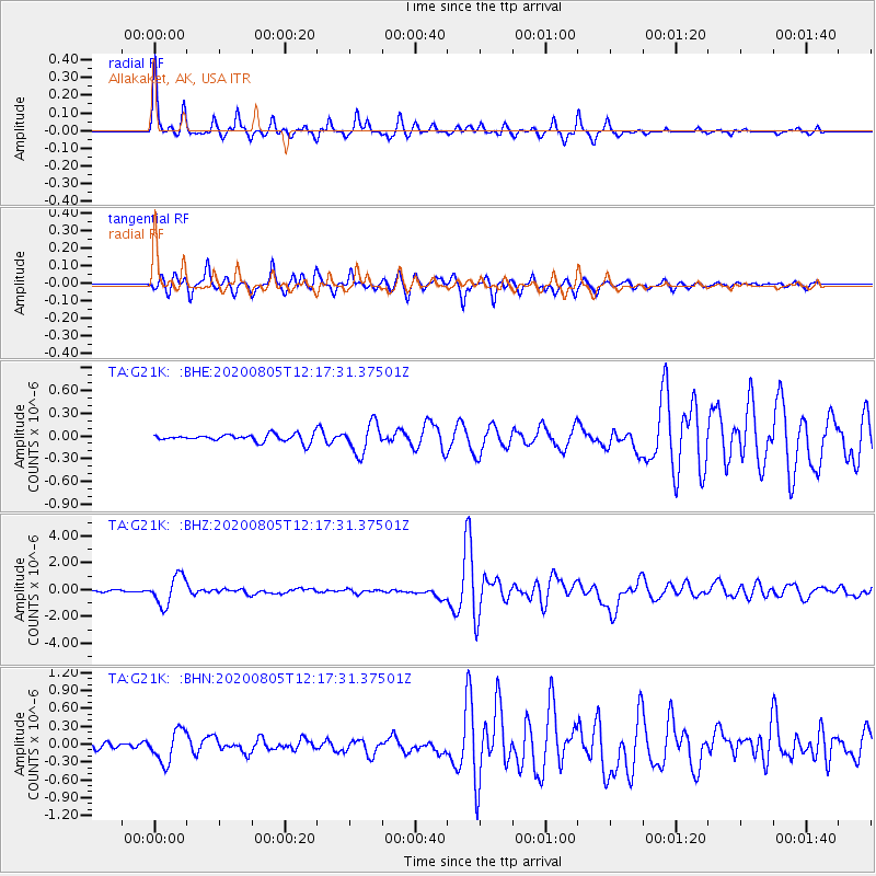
Signal To Noise
| Channel | StoN | STA | LTA |
| TA:G21K: :BHZ:20200805T12:17:31.37501Z | 18.874252 | 1.0768266E-6 | 5.705268E-8 |
| TA:G21K: :BHN:20200805T12:17:31.37501Z | 5.1457124 | 2.6681693E-7 | 5.1852282E-8 |
| TA:G21K: :BHE:20200805T12:17:31.37501Z | 3.9161246 | 1.9573702E-7 | 4.998233E-8 |
| Arrivals |
| Ps | 4.4 SECOND |
| PpPs | 13 SECOND |
| PsPs/PpSs | 17 SECOND |


