You are here: Home > Network List > TA - USArray Transportable Network (new EarthScope stations) Stations List
> Station G22K Bettles, AK, USA > Earthquake Result Viewer
G22K Bettles, AK, USA - Earthquake Result Viewer
| Earthquake location: |
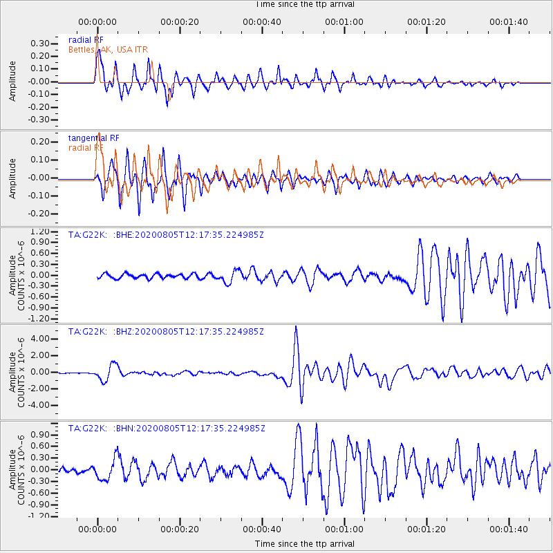
Vanuatu Islands |
| Earthquake latitude/longitude: |
-16.1/168.1 |
| Earthquake time(UTC): |
2020/08/05 (218) 12:05:36 GMT |
| Earthquake Depth: |
175 km |
| Earthquake Magnitude: |
6.4 mww |
| Earthquake Catalog/Contributor: |
NEIC PDE/us |
|
| Network: |
TA USArray Transportable Network (new EarthScope stations) |
| Station: |
G22K Bettles, AK, USA |
| Lat/Lon: |
66.92 N/151.51 W |
| Elevation: |
205 m |
|
| Distance: |
88.0 deg |
| Az: |
14.816 deg |
| Baz: |
218.573 deg |
| Ray Param: |
0.04251946 |
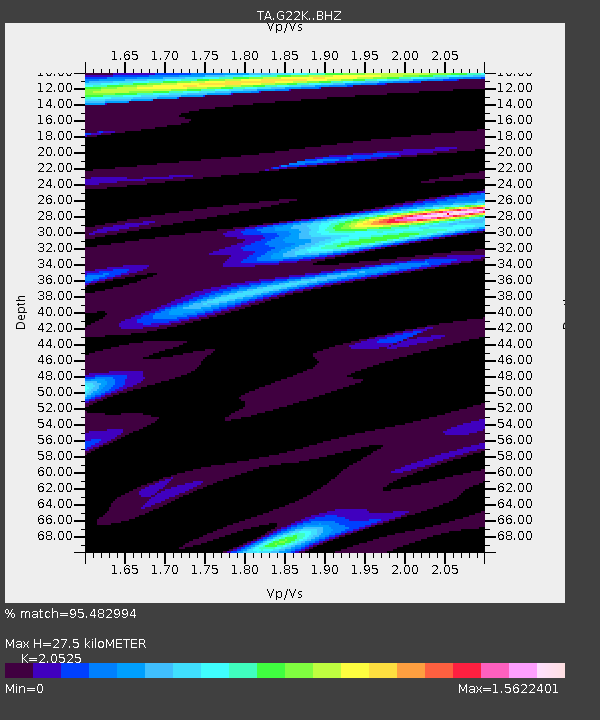
| Estimated Moho Depth: |
27.5 km |
| Estimated Crust Vp/Vs: |
2.05 |
| Assumed Crust Vp: |
6.577 km/s |
| Estimated Crust Vs: |
3.204 km/s |
| Estimated Crust Poisson's Ratio: |
0.34 |
|
| Radial Match: |
95.482994 % |
| Radial Bump: |
400 |
| Transverse Match: |
91.554855 % |
| Transverse Bump: |
343 |
| SOD ConfigId: |
21709731 |
| Insert Time: |
2020-08-19 12:23:51.239 +0000 |
| GWidth: |
2.5 |
| Max Bumps: |
400 |
| Tol: |
0.001 |
|
Signal To Noise
| Channel | StoN | STA | LTA |
| TA:G22K: :BHZ:20200805T12:17:35.224985Z | 16.646626 | 9.844362E-7 | 5.9137278E-8 |
| TA:G22K: :BHN:20200805T12:17:35.224985Z | 5.2115064 | 2.7963694E-7 | 5.36576E-8 |
| TA:G22K: :BHE:20200805T12:17:35.224985Z | 2.88501 | 1.7672822E-7 | 6.12574E-8 |
| Arrivals |
| Ps | 4.5 SECOND |
| PpPs | 13 SECOND |
| PsPs/PpSs | 17 SECOND |


