You are here: Home > Network List > US - United States National Seismic Network Stations List
> Station MIAR Mount Ida, Arkansas, USA > Earthquake Result Viewer
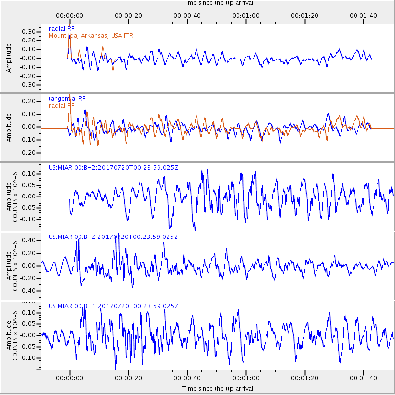
MIAR Mount Ida, Arkansas, USA - Earthquake Result Viewer
*The percent match for this event was below the threshold and hence no stack was calculated.
| Earthquake location: |
Near East Coast Of Honshu, Japan |
| Earthquake latitude/longitude: |
37.4/141.6 |
| Earthquake time(UTC): |
2017/07/20 (201) 00:11:25 GMT |
| Earthquake Depth: |
35 km |
| Earthquake Magnitude: |
5.8 Mww |
| Earthquake Catalog/Contributor: |
NEIC PDE/us |
|
| Network: |
US United States National Seismic Network |
| Station: |
MIAR Mount Ida, Arkansas, USA |
| Lat/Lon: |
34.55 N/93.58 W |
| Elevation: |
207 m |
|
| Distance: |
91.9 deg |
| Az: |
42.684 deg |
| Baz: |
319.166 deg |
| Ray Param: |
$rayparam |
*The percent match for this event was below the threshold and hence was not used in the summary stack. |
|
| Radial Match: |
65.38082 % |
| Radial Bump: |
400 |
| Transverse Match: |
63.119762 % |
| Transverse Bump: |
400 |
| SOD ConfigId: |
2140511 |
| Insert Time: |
2017-08-02 16:07:52.623 +0000 |
| GWidth: |
2.5 |
| Max Bumps: |
400 |
| Tol: |
0.001 |
|
Signal To Noise
| Channel | StoN | STA | LTA |
| US:MIAR:00:BHZ:20170720T00:23:59.025Z | 4.11767 | 1.9770613E-7 | 4.801408E-8 |
| US:MIAR:00:BH1:20170720T00:23:59.025Z | 2.184449 | 5.139345E-8 | 2.3526963E-8 |
| US:MIAR:00:BH2:20170720T00:23:59.025Z | 2.0477698 | 7.228547E-8 | 3.5299603E-8 |
| Arrivals |
| Ps | |
| PpPs | |
| PsPs/PpSs | |


