You are here: Home > Network List > TA - USArray Transportable Network (new EarthScope stations) Stations List
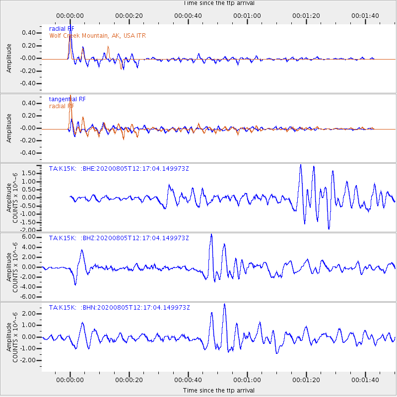
> Station K15K Wolf Creek Mountain, AK, USA > Earthquake Result Viewer
K15K Wolf Creek Mountain, AK, USA - Earthquake Result Viewer
| Earthquake location: |
Vanuatu Islands |
| Earthquake latitude/longitude: |
-16.1/168.1 |
| Earthquake time(UTC): |
2020/08/05 (218) 12:05:36 GMT |
| Earthquake Depth: |
175 km |
| Earthquake Magnitude: |
6.4 mww |
| Earthquake Catalog/Contributor: |
NEIC PDE/us |
|
| Network: |
TA USArray Transportable Network (new EarthScope stations) |
| Station: |
K15K Wolf Creek Mountain, AK, USA |
| Lat/Lon: |
62.29 N/161.53 W |
| Elevation: |
346 m |
|
| Distance: |
81.7 deg |
| Az: |
13.822 deg |
| Baz: |
209.428 deg |
| Ray Param: |
0.046958283 |
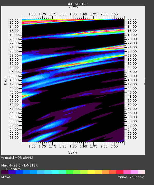
| Estimated Moho Depth: |
23.5 km |
| Estimated Crust Vp/Vs: |
2.10 |
| Assumed Crust Vp: |
6.276 km/s |
| Estimated Crust Vs: |
2.992 km/s |
| Estimated Crust Poisson's Ratio: |
0.35 |
|
| Radial Match: |
95.68443 % |
| Radial Bump: |
242 |
| Transverse Match: |
90.12385 % |
| Transverse Bump: |
375 |
| SOD ConfigId: |
21709731 |
| Insert Time: |
2020-08-19 12:24:29.247 +0000 |
| GWidth: |
2.5 |
| Max Bumps: |
400 |
| Tol: |
0.001 |
|
Signal To Noise
| Channel | StoN | STA | LTA |
| TA:K15K: :BHZ:20200805T12:17:04.149973Z | 15.761022 | 1.9757654E-6 | 1.2535769E-7 |
| TA:K15K: :BHN:20200805T12:17:04.149973Z | 10.02273 | 6.8640713E-7 | 6.848505E-8 |
| TA:K15K: :BHE:20200805T12:17:04.149973Z | 4.6053677 | 4.5308633E-7 | 9.838222E-8 |
| Arrivals |
| Ps | 4.2 SECOND |
| PpPs | 11 SECOND |
| PsPs/PpSs | 16 SECOND |


