You are here: Home > Network List > US - United States National Seismic Network Stations List
> Station MSO Missoula, Montana, USA > Earthquake Result Viewer
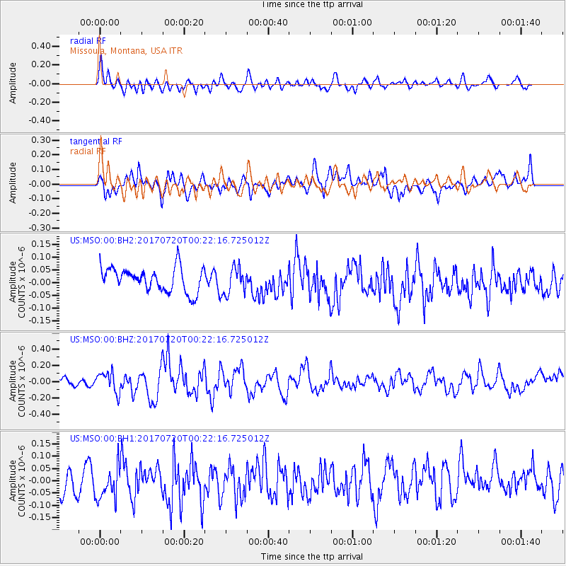
MSO Missoula, Montana, USA - Earthquake Result Viewer
*The percent match for this event was below the threshold and hence no stack was calculated.
| Earthquake location: |
Near East Coast Of Honshu, Japan |
| Earthquake latitude/longitude: |
37.4/141.6 |
| Earthquake time(UTC): |
2017/07/20 (201) 00:11:25 GMT |
| Earthquake Depth: |
35 km |
| Earthquake Magnitude: |
5.8 Mww |
| Earthquake Catalog/Contributor: |
NEIC PDE/us |
|
| Network: |
US United States National Seismic Network |
| Station: |
MSO Missoula, Montana, USA |
| Lat/Lon: |
46.83 N/113.94 W |
| Elevation: |
1264 m |
|
| Distance: |
72.3 deg |
| Az: |
44.246 deg |
| Baz: |
306.001 deg |
| Ray Param: |
$rayparam |
*The percent match for this event was below the threshold and hence was not used in the summary stack. |
|
| Radial Match: |
61.659058 % |
| Radial Bump: |
400 |
| Transverse Match: |
54.53983 % |
| Transverse Bump: |
400 |
| SOD ConfigId: |
2140511 |
| Insert Time: |
2017-08-02 16:07:55.822 +0000 |
| GWidth: |
2.5 |
| Max Bumps: |
400 |
| Tol: |
0.001 |
|
Signal To Noise
| Channel | StoN | STA | LTA |
| US:MSO:00:BHZ:20170720T00:22:16.725012Z | 2.0640774 | 1.291342E-7 | 6.256267E-8 |
| US:MSO:00:BH1:20170720T00:22:16.725012Z | 1.4344338 | 7.088494E-8 | 4.9416663E-8 |
| US:MSO:00:BH2:20170720T00:22:16.725012Z | 1.1052021 | 5.131362E-8 | 4.6429175E-8 |
| Arrivals |
| Ps | |
| PpPs | |
| PsPs/PpSs | |


