You are here: Home > Network List > TA - USArray Transportable Network (new EarthScope stations) Stations List
> Station L15K Ungalak Mountain, AK, USA > Earthquake Result Viewer
L15K Ungalak Mountain, AK, USA - Earthquake Result Viewer
| Earthquake location: |
Vanuatu Islands |
| Earthquake latitude/longitude: |
-16.1/168.1 |
| Earthquake time(UTC): |
2020/08/05 (218) 12:05:36 GMT |
| Earthquake Depth: |
175 km |
| Earthquake Magnitude: |
6.4 mww |
| Earthquake Catalog/Contributor: |
NEIC PDE/us |
|
| Network: |
TA USArray Transportable Network (new EarthScope stations) |
| Station: |
L15K Ungalak Mountain, AK, USA |
| Lat/Lon: |
61.68 N/161.49 W |
| Elevation: |
219 m |
|
| Distance: |
81.2 deg |
| Az: |
14.148 deg |
| Baz: |
209.515 deg |
| Ray Param: |
0.047324173 |
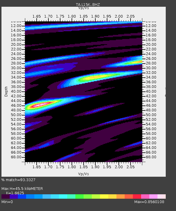
| Estimated Moho Depth: |
45.5 km |
| Estimated Crust Vp/Vs: |
1.66 |
| Assumed Crust Vp: |
6.182 km/s |
| Estimated Crust Vs: |
3.719 km/s |
| Estimated Crust Poisson's Ratio: |
0.22 |
|
| Radial Match: |
93.3327 % |
| Radial Bump: |
221 |
| Transverse Match: |
85.244156 % |
| Transverse Bump: |
316 |
| SOD ConfigId: |
21709731 |
| Insert Time: |
2020-08-19 12:24:34.653 +0000 |
| GWidth: |
2.5 |
| Max Bumps: |
400 |
| Tol: |
0.001 |
|
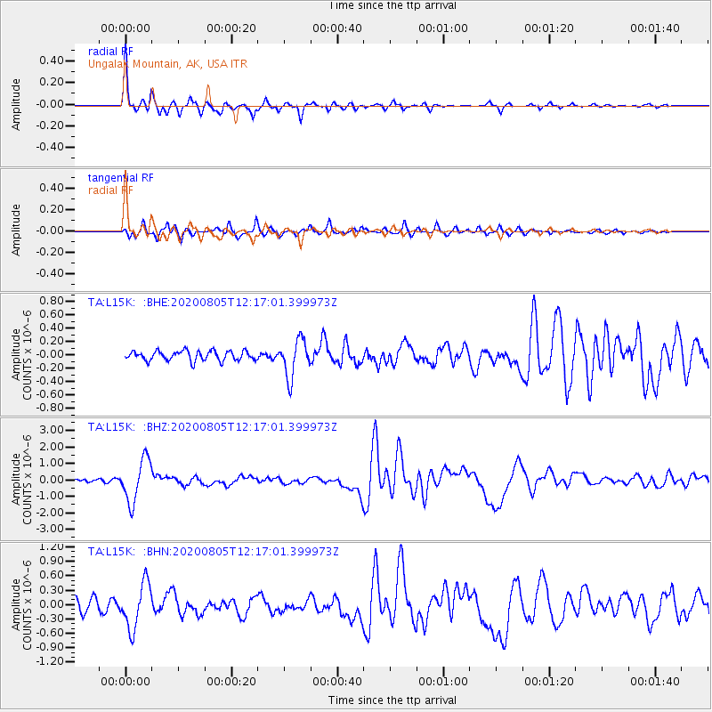
Signal To Noise
| Channel | StoN | STA | LTA |
| TA:L15K: :BHZ:20200805T12:17:01.399973Z | 14.853263 | 1.3006689E-6 | 8.756789E-8 |
| TA:L15K: :BHN:20200805T12:17:01.399973Z | 4.568122 | 4.7604053E-7 | 1.04209235E-7 |
| TA:L15K: :BHE:20200805T12:17:01.399973Z | 3.9050972 | 2.7887617E-7 | 7.1413375E-8 |
| Arrivals |
| Ps | 5.0 SECOND |
| PpPs | 19 SECOND |
| PsPs/PpSs | 24 SECOND |


