You are here: Home > Network List > TA - USArray Transportable Network (new EarthScope stations) Stations List
> Station M18K Stony River, AK, USA > Earthquake Result Viewer
M18K Stony River, AK, USA - Earthquake Result Viewer
| Earthquake location: |
Vanuatu Islands |
| Earthquake latitude/longitude: |
-16.1/168.1 |
| Earthquake time(UTC): |
2020/08/05 (218) 12:05:36 GMT |
| Earthquake Depth: |
175 km |
| Earthquake Magnitude: |
6.4 mww |
| Earthquake Catalog/Contributor: |
NEIC PDE/us |
|
| Network: |
TA USArray Transportable Network (new EarthScope stations) |
| Station: |
M18K Stony River, AK, USA |
| Lat/Lon: |
61.49 N/155.82 W |
| Elevation: |
289 m |
|
| Distance: |
82.5 deg |
| Az: |
16.564 deg |
| Baz: |
214.831 deg |
| Ray Param: |
0.046438437 |
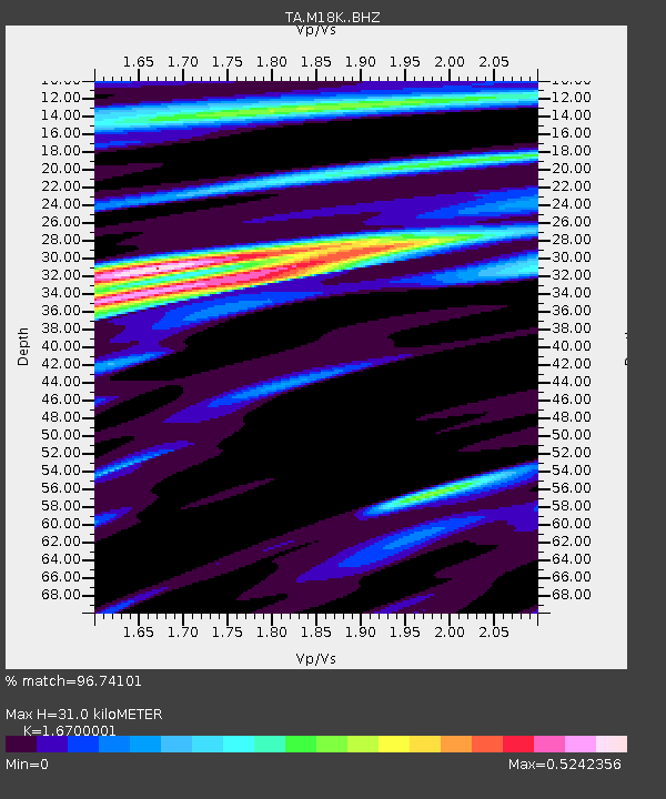
| Estimated Moho Depth: |
31.0 km |
| Estimated Crust Vp/Vs: |
1.67 |
| Assumed Crust Vp: |
6.566 km/s |
| Estimated Crust Vs: |
3.932 km/s |
| Estimated Crust Poisson's Ratio: |
0.22 |
|
| Radial Match: |
96.74101 % |
| Radial Bump: |
283 |
| Transverse Match: |
90.38252 % |
| Transverse Bump: |
400 |
| SOD ConfigId: |
21709731 |
| Insert Time: |
2020-08-19 12:24:48.639 +0000 |
| GWidth: |
2.5 |
| Max Bumps: |
400 |
| Tol: |
0.001 |
|

Signal To Noise
| Channel | StoN | STA | LTA |
| TA:M18K: :BHZ:20200805T12:17:08.075022Z | 25.450157 | 2.5487063E-6 | 1.0014501E-7 |
| TA:M18K: :BHN:20200805T12:17:08.075022Z | 5.011242 | 5.842831E-7 | 1.16594464E-7 |
| TA:M18K: :BHE:20200805T12:17:08.075022Z | 4.423226 | 4.6582178E-7 | 1.0531268E-7 |
| Arrivals |
| Ps | 3.3 SECOND |
| PpPs | 12 SECOND |
| PsPs/PpSs | 16 SECOND |


