You are here: Home > Network List > TA - USArray Transportable Network (new EarthScope stations) Stations List
> Station N17K Nushagak Hills, AK, USA > Earthquake Result Viewer
N17K Nushagak Hills, AK, USA - Earthquake Result Viewer
| Earthquake location: |
Vanuatu Islands |
| Earthquake latitude/longitude: |
-16.1/168.1 |
| Earthquake time(UTC): |
2020/08/05 (218) 12:05:36 GMT |
| Earthquake Depth: |
175 km |
| Earthquake Magnitude: |
6.4 mww |
| Earthquake Catalog/Contributor: |
NEIC PDE/us |
|
| Network: |
TA USArray Transportable Network (new EarthScope stations) |
| Station: |
N17K Nushagak Hills, AK, USA |
| Lat/Lon: |
60.53 N/157.19 W |
| Elevation: |
350 m |
|
| Distance: |
81.3 deg |
| Az: |
16.56 deg |
| Baz: |
213.641 deg |
| Ray Param: |
0.047246028 |
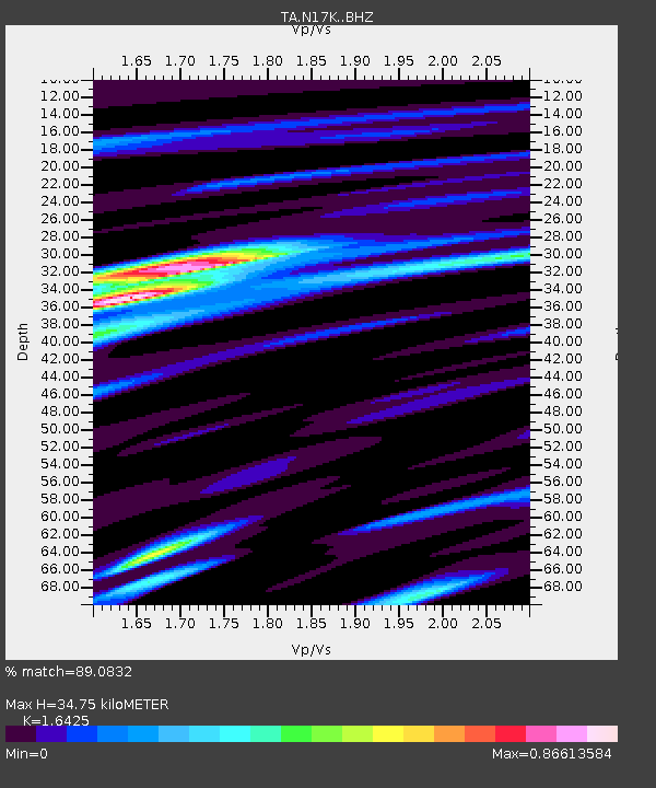
| Estimated Moho Depth: |
34.75 km |
| Estimated Crust Vp/Vs: |
1.64 |
| Assumed Crust Vp: |
6.155 km/s |
| Estimated Crust Vs: |
3.747 km/s |
| Estimated Crust Poisson's Ratio: |
0.21 |
|
| Radial Match: |
89.0832 % |
| Radial Bump: |
328 |
| Transverse Match: |
73.810524 % |
| Transverse Bump: |
400 |
| SOD ConfigId: |
21709731 |
| Insert Time: |
2020-08-19 12:24:59.626 +0000 |
| GWidth: |
2.5 |
| Max Bumps: |
400 |
| Tol: |
0.001 |
|

Signal To Noise
| Channel | StoN | STA | LTA |
| TA:N17K: :BHZ:20200805T12:17:01.974985Z | 14.232145 | 1.4867256E-6 | 1.0446251E-7 |
| TA:N17K: :BHN:20200805T12:17:01.974985Z | 2.8421419 | 4.3407607E-7 | 1.527285E-7 |
| TA:N17K: :BHE:20200805T12:17:01.974985Z | 2.9342403 | 2.3679915E-7 | 8.070203E-8 |
| Arrivals |
| Ps | 3.7 SECOND |
| PpPs | 15 SECOND |
| PsPs/PpSs | 18 SECOND |


