You are here: Home > Network List > TA - USArray Transportable Network (new EarthScope stations) Stations List
> Station N30M Aishikik Lake, Yukon, CAN > Earthquake Result Viewer
N30M Aishikik Lake, Yukon, CAN - Earthquake Result Viewer
| Earthquake location: |
Vanuatu Islands |
| Earthquake latitude/longitude: |
-16.1/168.1 |
| Earthquake time(UTC): |
2020/08/05 (218) 12:05:36 GMT |
| Earthquake Depth: |
175 km |
| Earthquake Magnitude: |
6.4 mww |
| Earthquake Catalog/Contributor: |
NEIC PDE/us |
|
| Network: |
TA USArray Transportable Network (new EarthScope stations) |
| Station: |
N30M Aishikik Lake, Yukon, CAN |
| Lat/Lon: |
61.46 N/137.09 W |
| Elevation: |
941 m |
|
| Distance: |
88.6 deg |
| Az: |
23.123 deg |
| Baz: |
231.81 deg |
| Ray Param: |
0.04206124 |
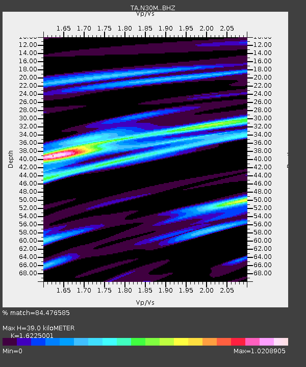
| Estimated Moho Depth: |
39.0 km |
| Estimated Crust Vp/Vs: |
1.62 |
| Assumed Crust Vp: |
6.566 km/s |
| Estimated Crust Vs: |
4.047 km/s |
| Estimated Crust Poisson's Ratio: |
0.19 |
|
| Radial Match: |
84.476585 % |
| Radial Bump: |
400 |
| Transverse Match: |
64.423904 % |
| Transverse Bump: |
400 |
| SOD ConfigId: |
21709731 |
| Insert Time: |
2020-08-19 12:25:02.025 +0000 |
| GWidth: |
2.5 |
| Max Bumps: |
400 |
| Tol: |
0.001 |
|

Signal To Noise
| Channel | StoN | STA | LTA |
| TA:N30M: :BHZ:20200805T12:17:38.200022Z | 4.3825336 | 3.339954E-7 | 7.621057E-8 |
| TA:N30M: :BHN:20200805T12:17:38.200022Z | 1.7427502 | 8.614982E-8 | 4.9433254E-8 |
| TA:N30M: :BHE:20200805T12:17:38.200022Z | 1.872448 | 9.7376905E-8 | 5.200513E-8 |
| Arrivals |
| Ps | 3.8 SECOND |
| PpPs | 15 SECOND |
| PsPs/PpSs | 19 SECOND |


