You are here: Home > Network List > TA - USArray Transportable Network (new EarthScope stations) Stations List
> Station Q32M Nakina River, BC, CAN > Earthquake Result Viewer
Q32M Nakina River, BC, CAN - Earthquake Result Viewer
| Earthquake location: |
Vanuatu Islands |
| Earthquake latitude/longitude: |
-16.1/168.1 |
| Earthquake time(UTC): |
2020/08/05 (218) 12:05:36 GMT |
| Earthquake Depth: |
175 km |
| Earthquake Magnitude: |
6.4 mww |
| Earthquake Catalog/Contributor: |
NEIC PDE/us |
|
| Network: |
TA USArray Transportable Network (new EarthScope stations) |
| Station: |
Q32M Nakina River, BC, CAN |
| Lat/Lon: |
58.96 N/132.27 W |
| Elevation: |
1951 m |
|
| Distance: |
89.1 deg |
| Az: |
26.565 deg |
| Baz: |
236.056 deg |
| Ray Param: |
0.041733243 |
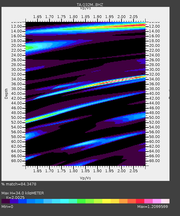
| Estimated Moho Depth: |
34.0 km |
| Estimated Crust Vp/Vs: |
2.00 |
| Assumed Crust Vp: |
6.597 km/s |
| Estimated Crust Vs: |
3.295 km/s |
| Estimated Crust Poisson's Ratio: |
0.33 |
|
| Radial Match: |
84.3478 % |
| Radial Bump: |
400 |
| Transverse Match: |
71.62991 % |
| Transverse Bump: |
400 |
| SOD ConfigId: |
21709731 |
| Insert Time: |
2020-08-19 12:25:23.249 +0000 |
| GWidth: |
2.5 |
| Max Bumps: |
400 |
| Tol: |
0.001 |
|

Signal To Noise
| Channel | StoN | STA | LTA |
| TA:Q32M: :BHZ:20200805T12:17:40.399973Z | 3.6223822 | 4.88762E-7 | 1.3492833E-7 |
| TA:Q32M: :BHN:20200805T12:17:40.399973Z | 2.0423257 | 2.1244844E-7 | 1.040228E-7 |
| TA:Q32M: :BHE:20200805T12:17:40.399973Z | 0.77264625 | 1.2077723E-7 | 1.5631633E-7 |
| Arrivals |
| Ps | 5.3 SECOND |
| PpPs | 15 SECOND |
| PsPs/PpSs | 20 SECOND |


