You are here: Home > Network List > US - United States National Seismic Network Stations List
> Station HAWA Hanford, Washington, USA > Earthquake Result Viewer
HAWA Hanford, Washington, USA - Earthquake Result Viewer
| Earthquake location: |
Vanuatu Islands |
| Earthquake latitude/longitude: |
-16.1/168.1 |
| Earthquake time(UTC): |
2020/08/05 (218) 12:05:36 GMT |
| Earthquake Depth: |
175 km |
| Earthquake Magnitude: |
6.4 mww |
| Earthquake Catalog/Contributor: |
NEIC PDE/us |
|
| Network: |
US United States National Seismic Network |
| Station: |
HAWA Hanford, Washington, USA |
| Lat/Lon: |
46.39 N/119.53 W |
| Elevation: |
364 m |
|
| Distance: |
89.9 deg |
| Az: |
41.276 deg |
| Baz: |
246.37 deg |
| Ray Param: |
0.04170651 |
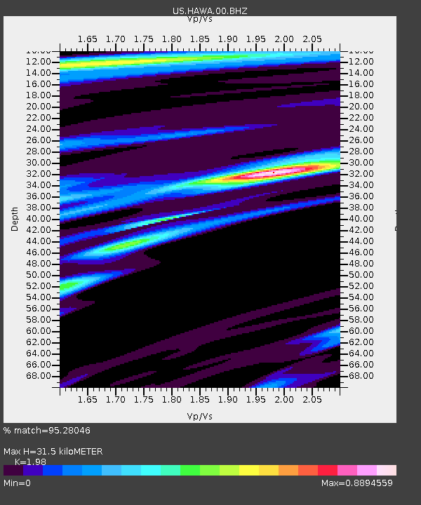
| Estimated Moho Depth: |
31.5 km |
| Estimated Crust Vp/Vs: |
1.98 |
| Assumed Crust Vp: |
6.419 km/s |
| Estimated Crust Vs: |
3.242 km/s |
| Estimated Crust Poisson's Ratio: |
0.33 |
|
| Radial Match: |
95.28046 % |
| Radial Bump: |
375 |
| Transverse Match: |
91.01353 % |
| Transverse Bump: |
330 |
| SOD ConfigId: |
21709731 |
| Insert Time: |
2020-08-19 12:26:55.400 +0000 |
| GWidth: |
2.5 |
| Max Bumps: |
400 |
| Tol: |
0.001 |
|

Signal To Noise
| Channel | StoN | STA | LTA |
| US:HAWA:00:BHZ:20200805T12:17:43.974009Z | 5.9784408 | 3.2536911E-7 | 5.442374E-8 |
| US:HAWA:00:BH1:20200805T12:17:43.974009Z | 0.96111 | 5.2280345E-8 | 5.43958E-8 |
| US:HAWA:00:BH2:20200805T12:17:43.974009Z | 1.962619 | 8.580624E-8 | 4.3720277E-8 |
| Arrivals |
| Ps | 4.9 SECOND |
| PpPs | 14 SECOND |
| PsPs/PpSs | 19 SECOND |


