You are here: Home > Network List > US - United States National Seismic Network Stations List
> Station WVOR Wild Horse Valley, Oregon, USA > Earthquake Result Viewer
WVOR Wild Horse Valley, Oregon, USA - Earthquake Result Viewer
| Earthquake location: |
Vanuatu Islands |
| Earthquake latitude/longitude: |
-16.1/168.1 |
| Earthquake time(UTC): |
2020/08/05 (218) 12:05:36 GMT |
| Earthquake Depth: |
175 km |
| Earthquake Magnitude: |
6.4 mww |
| Earthquake Catalog/Contributor: |
NEIC PDE/us |
|
| Network: |
US United States National Seismic Network |
| Station: |
WVOR Wild Horse Valley, Oregon, USA |
| Lat/Lon: |
42.43 N/118.64 W |
| Elevation: |
1344 m |
|
| Distance: |
88.9 deg |
| Az: |
45.166 deg |
| Baz: |
247.037 deg |
| Ray Param: |
0.041863754 |
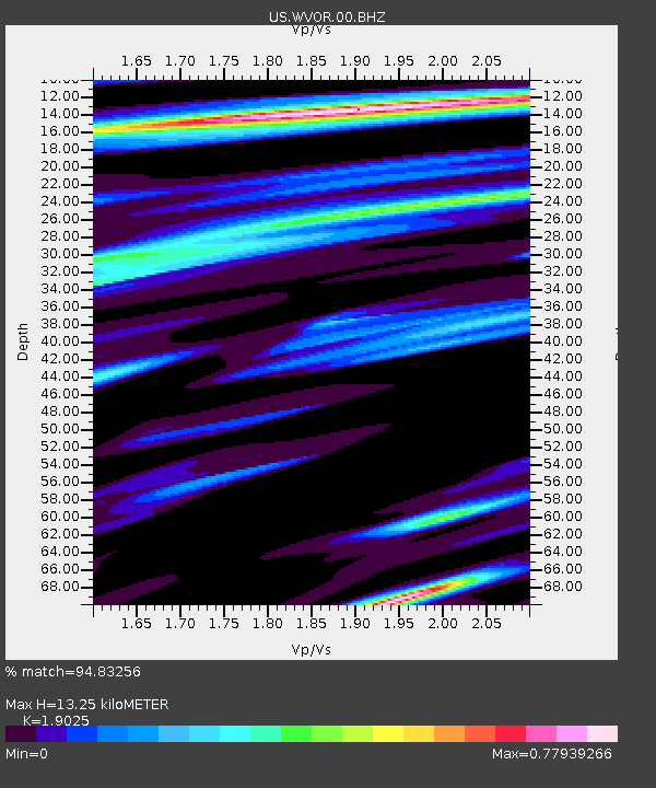
| Estimated Moho Depth: |
13.25 km |
| Estimated Crust Vp/Vs: |
1.90 |
| Assumed Crust Vp: |
6.279 km/s |
| Estimated Crust Vs: |
3.3 km/s |
| Estimated Crust Poisson's Ratio: |
0.31 |
|
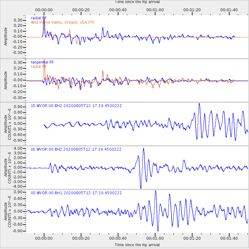
| Radial Match: |
94.83256 % |
| Radial Bump: |
400 |
| Transverse Match: |
93.19136 % |
| Transverse Bump: |
400 |
| SOD ConfigId: |
21709731 |
| Insert Time: |
2020-08-19 12:27:12.517 +0000 |
| GWidth: |
2.5 |
| Max Bumps: |
400 |
| Tol: |
0.001 |
|
Signal To Noise
| Channel | StoN | STA | LTA |
| US:WVOR:00:BHZ:20200805T12:17:39.450022Z | 8.157883 | 4.3569054E-7 | 5.3407305E-8 |
| US:WVOR:00:BH1:20200805T12:17:39.450022Z | 1.4094493 | 9.306885E-8 | 6.603206E-8 |
| US:WVOR:00:BH2:20200805T12:17:39.450022Z | 1.3172479 | 9.971715E-8 | 7.5701124E-8 |
| Arrivals |
| Ps | 1.9 SECOND |
| PpPs | 6.0 SECOND |
| PsPs/PpSs | 8.0 SECOND |


