You are here: Home > Network List > UU - University of Utah Regional Network Stations List
> Station MTPU Mt. Pierson, UT, USA > Earthquake Result Viewer
MTPU Mt. Pierson, UT, USA - Earthquake Result Viewer
| Earthquake location: |
Vanuatu Islands |
| Earthquake latitude/longitude: |
-16.1/168.1 |
| Earthquake time(UTC): |
2020/08/05 (218) 12:05:36 GMT |
| Earthquake Depth: |
175 km |
| Earthquake Magnitude: |
6.4 mww |
| Earthquake Catalog/Contributor: |
NEIC PDE/us |
|
| Network: |
UU University of Utah Regional Network |
| Station: |
MTPU Mt. Pierson, UT, USA |
| Lat/Lon: |
38.04 N/112.18 W |
| Elevation: |
3112 m |
|
| Distance: |
91.9 deg |
| Az: |
51.021 deg |
| Baz: |
251.151 deg |
| Ray Param: |
0.041452684 |
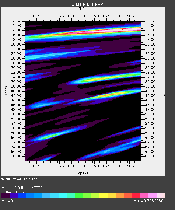
| Estimated Moho Depth: |
13.5 km |
| Estimated Crust Vp/Vs: |
2.02 |
| Assumed Crust Vp: |
6.276 km/s |
| Estimated Crust Vs: |
3.111 km/s |
| Estimated Crust Poisson's Ratio: |
0.34 |
|
| Radial Match: |
88.96975 % |
| Radial Bump: |
400 |
| Transverse Match: |
75.531944 % |
| Transverse Bump: |
400 |
| SOD ConfigId: |
21709731 |
| Insert Time: |
2020-08-19 12:27:38.402 +0000 |
| GWidth: |
2.5 |
| Max Bumps: |
400 |
| Tol: |
0.001 |
|

Signal To Noise
| Channel | StoN | STA | LTA |
| UU:MTPU:01:HHZ:20200805T12:17:53.568003Z | 4.8643894 | 9.0212895E-9 | 1.8545575E-9 |
| UU:MTPU:01:HHN:20200805T12:17:53.568003Z | 1.252335 | 2.3794273E-9 | 1.8999926E-9 |
| UU:MTPU:01:HHE:20200805T12:17:53.568003Z | 0.9669305 | 2.6201958E-9 | 2.709808E-9 |
| Arrivals |
| Ps | 2.2 SECOND |
| PpPs | 6.4 SECOND |
| PsPs/PpSs | 8.6 SECOND |


