You are here: Home > Network List > UW - Pacific Northwest Regional Seismic Network Stations List
> Station LON Longmire CREST broad-band > Earthquake Result Viewer
LON Longmire CREST broad-band - Earthquake Result Viewer
| Earthquake location: |
Vanuatu Islands |
| Earthquake latitude/longitude: |
-16.1/168.1 |
| Earthquake time(UTC): |
2020/08/05 (218) 12:05:36 GMT |
| Earthquake Depth: |
175 km |
| Earthquake Magnitude: |
6.4 mww |
| Earthquake Catalog/Contributor: |
NEIC PDE/us |
|
| Network: |
UW Pacific Northwest Regional Seismic Network |
| Station: |
LON Longmire CREST broad-band |
| Lat/Lon: |
46.75 N/121.81 W |
| Elevation: |
853 m |
|
| Distance: |
88.6 deg |
| Az: |
40.3 deg |
| Baz: |
244.708 deg |
| Ray Param: |
0.042087443 |
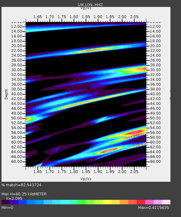
| Estimated Moho Depth: |
60.25 km |
| Estimated Crust Vp/Vs: |
2.10 |
| Assumed Crust Vp: |
6.597 km/s |
| Estimated Crust Vs: |
3.149 km/s |
| Estimated Crust Poisson's Ratio: |
0.35 |
|
| Radial Match: |
92.543724 % |
| Radial Bump: |
259 |
| Transverse Match: |
66.98903 % |
| Transverse Bump: |
344 |
| SOD ConfigId: |
21709731 |
| Insert Time: |
2020-08-19 12:28:35.524 +0000 |
| GWidth: |
2.5 |
| Max Bumps: |
400 |
| Tol: |
0.001 |
|
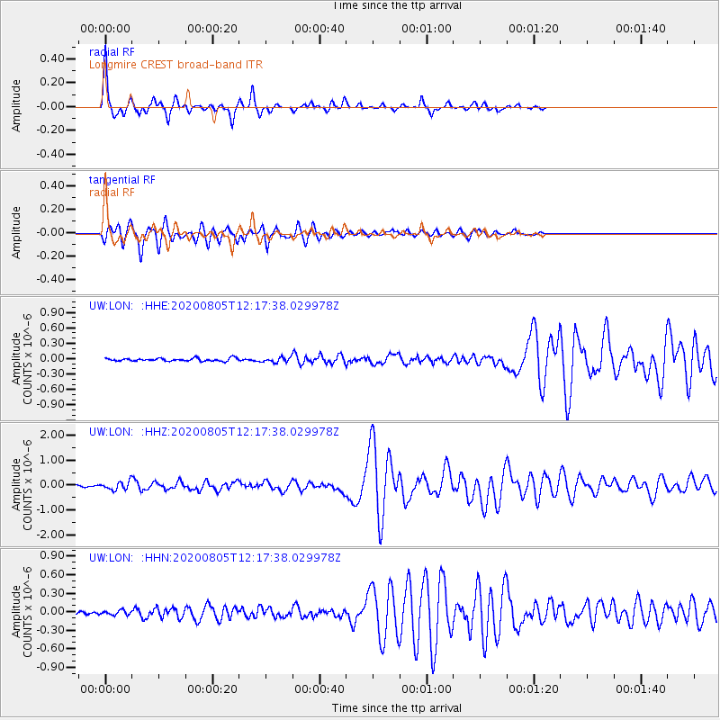
Signal To Noise
| Channel | StoN | STA | LTA |
| UW:LON: :HHZ:20200805T12:17:38.029978Z | 3.1436474 | 1.595702E-7 | 5.0759574E-8 |
| UW:LON: :HHN:20200805T12:17:38.029978Z | 1.5029253 | 3.7402014E-8 | 2.4886145E-8 |
| UW:LON: :HHE:20200805T12:17:38.029978Z | 1.7327507 | 4.691821E-8 | 2.70773E-8 |
| Arrivals |
| Ps | 10 SECOND |
| PpPs | 28 SECOND |
| PsPs/PpSs | 38 SECOND |


