You are here: Home > Network List > UW - Pacific Northwest Regional Seismic Network Stations List
> Station LTY Liberty (broad-band) > Earthquake Result Viewer
LTY Liberty (broad-band) - Earthquake Result Viewer
| Earthquake location: |
Vanuatu Islands |
| Earthquake latitude/longitude: |
-16.1/168.1 |
| Earthquake time(UTC): |
2020/08/05 (218) 12:05:36 GMT |
| Earthquake Depth: |
175 km |
| Earthquake Magnitude: |
6.4 mww |
| Earthquake Catalog/Contributor: |
NEIC PDE/us |
|
| Network: |
UW Pacific Northwest Regional Seismic Network |
| Station: |
LTY Liberty (broad-band) |
| Lat/Lon: |
47.26 N/120.66 W |
| Elevation: |
970 m |
|
| Distance: |
89.5 deg |
| Az: |
40.171 deg |
| Baz: |
245.541 deg |
| Ray Param: |
0.04172465 |
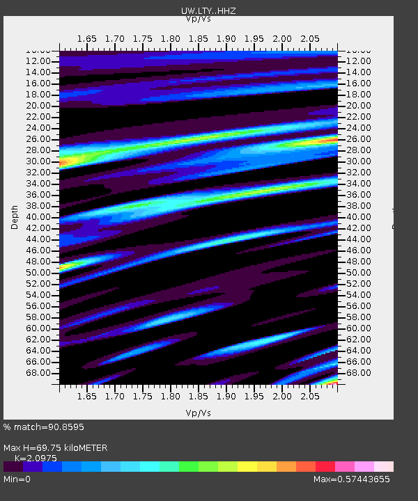
| Estimated Moho Depth: |
69.75 km |
| Estimated Crust Vp/Vs: |
2.10 |
| Assumed Crust Vp: |
6.597 km/s |
| Estimated Crust Vs: |
3.145 km/s |
| Estimated Crust Poisson's Ratio: |
0.35 |
|
| Radial Match: |
90.8595 % |
| Radial Bump: |
364 |
| Transverse Match: |
94.88982 % |
| Transverse Bump: |
308 |
| SOD ConfigId: |
21709731 |
| Insert Time: |
2020-08-19 12:28:38.560 +0000 |
| GWidth: |
2.5 |
| Max Bumps: |
400 |
| Tol: |
0.001 |
|
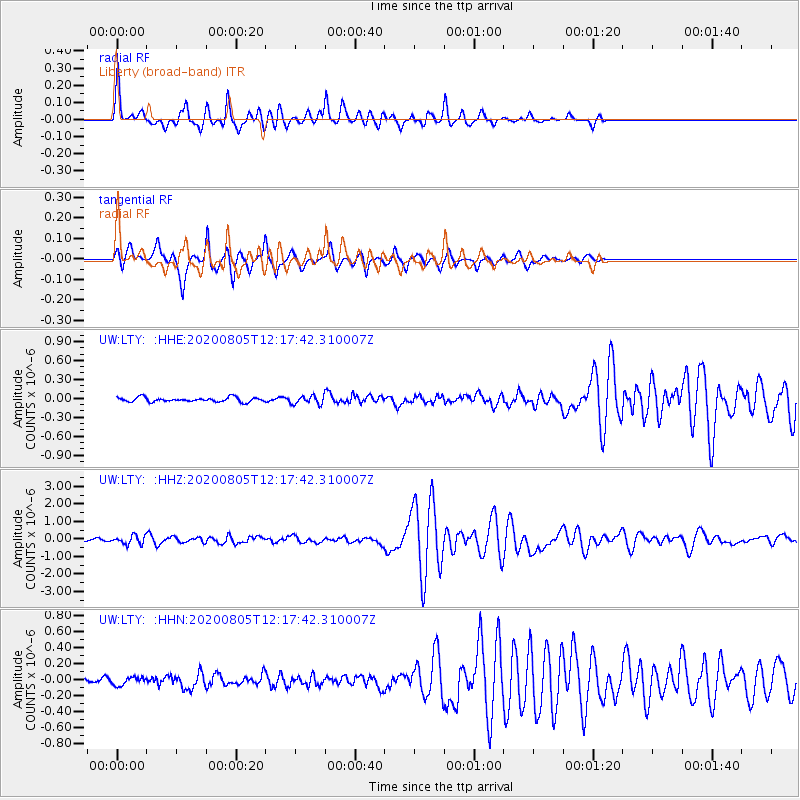
Signal To Noise
| Channel | StoN | STA | LTA |
| UW:LTY: :HHZ:20200805T12:17:42.310007Z | 4.206723 | 2.4002279E-7 | 5.7056948E-8 |
| UW:LTY: :HHN:20200805T12:17:42.310007Z | 1.211386 | 5.0098244E-8 | 4.1356135E-8 |
| UW:LTY: :HHE:20200805T12:17:42.310007Z | 1.8127003 | 6.34323E-8 | 3.4993267E-8 |
| Arrivals |
| Ps | 12 SECOND |
| PpPs | 32 SECOND |
| PsPs/PpSs | 44 SECOND |


