You are here: Home > Network List > UW - Pacific Northwest Regional Seismic Network Stations List
> Station UMAT Pilot Rock, OR, USA > Earthquake Result Viewer
UMAT Pilot Rock, OR, USA - Earthquake Result Viewer

| Earthquake location: |
Vanuatu Islands |
| Earthquake latitude/longitude: |
-16.1/168.1 |
| Earthquake time(UTC): |
2020/08/05 (218) 12:05:36 GMT |
| Earthquake Depth: |
175 km |
| Earthquake Magnitude: |
6.4 mww |
| Earthquake Catalog/Contributor: |
NEIC PDE/us |
|
| Network: |
UW Pacific Northwest Regional Seismic Network |
| Station: |
UMAT Pilot Rock, OR, USA |
| Lat/Lon: |
45.29 N/118.96 W |
| Elevation: |
1318 m |
|
| Distance: |
89.8 deg |
| Az: |
42.447 deg |
| Baz: |
246.783 deg |
| Ray Param: |
0.041710805 |
| Estimated Moho Depth: |
53.75 km |
| Estimated Crust Vp/Vs: |
1.60 |
| Assumed Crust Vp: |
6.571 km/s |
| Estimated Crust Vs: |
4.107 km/s |
| Estimated Crust Poisson's Ratio: |
0.18 |
|
| Radial Match: |
96.590454 % |
| Radial Bump: |
217 |
| Transverse Match: |
92.943 % |
| Transverse Bump: |
369 |
| SOD ConfigId: |
21709731 |
| Insert Time: |
2020-08-19 12:29:09.569 +0000 |
| GWidth: |
2.5 |
| Max Bumps: |
400 |
| Tol: |
0.001 |
|
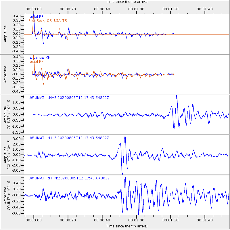
Signal To Noise
| Channel | StoN | STA | LTA |
| UW:UMAT: :HHZ:20200805T12:17:43.64802Z | 4.3814626 | 2.7826619E-7 | 6.350989E-8 |
| UW:UMAT: :HHN:20200805T12:17:43.64802Z | 0.9304491 | 4.930069E-8 | 5.2985907E-8 |
| UW:UMAT: :HHE:20200805T12:17:43.64802Z | 1.7654425 | 9.514788E-8 | 5.3894635E-8 |
| Arrivals |
| Ps | 5.0 SECOND |
| PpPs | 21 SECOND |
| PsPs/PpSs | 26 SECOND |


