You are here: Home > Network List > US - United States National Seismic Network Stations List
> Station AMTX Amarillo, Texas, USA > Earthquake Result Viewer
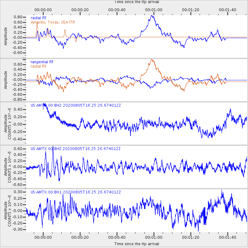
AMTX Amarillo, Texas, USA - Earthquake Result Viewer
*The percent match for this event was below the threshold and hence no stack was calculated.
| Earthquake location: |
Alaska Peninsula |
| Earthquake latitude/longitude: |
54.6/-161.2 |
| Earthquake time(UTC): |
2020/08/05 (218) 16:17:40 GMT |
| Earthquake Depth: |
4.8 km |
| Earthquake Magnitude: |
5.2 Mww |
| Earthquake Catalog/Contributor: |
NEIC PDE/us |
|
| Network: |
US United States National Seismic Network |
| Station: |
AMTX Amarillo, Texas, USA |
| Lat/Lon: |
34.53 N/101.41 W |
| Elevation: |
1010 m |
|
| Distance: |
45.5 deg |
| Az: |
90.764 deg |
| Baz: |
315.193 deg |
| Ray Param: |
$rayparam |
*The percent match for this event was below the threshold and hence was not used in the summary stack. |
|
| Radial Match: |
22.940802 % |
| Radial Bump: |
400 |
| Transverse Match: |
30.395351 % |
| Transverse Bump: |
400 |
| SOD ConfigId: |
21709731 |
| Insert Time: |
2020-08-19 16:36:15.879 +0000 |
| GWidth: |
2.5 |
| Max Bumps: |
400 |
| Tol: |
0.001 |
|
Signal To Noise
| Channel | StoN | STA | LTA |
| US:AMTX:00:BHZ:20200805T16:25:26.674012Z | 3.4138858 | 2.145098E-7 | 6.2834495E-8 |
| US:AMTX:00:BH1:20200805T16:25:26.674012Z | 1.3202578 | 1.0981927E-7 | 8.318017E-8 |
| US:AMTX:00:BH2:20200805T16:25:26.674012Z | 1.0509315 | 1.2336079E-7 | 1.1738234E-7 |
| Arrivals |
| Ps | |
| PpPs | |
| PsPs/PpSs | |


