You are here: Home > Network List > US - United States National Seismic Network Stations List
> Station CBKS Cedar Bluff, Kansas, USA > Earthquake Result Viewer
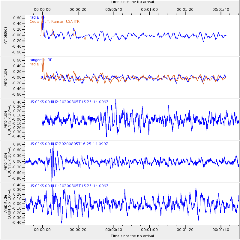
CBKS Cedar Bluff, Kansas, USA - Earthquake Result Viewer
*The percent match for this event was below the threshold and hence no stack was calculated.
| Earthquake location: |
Alaska Peninsula |
| Earthquake latitude/longitude: |
54.6/-161.2 |
| Earthquake time(UTC): |
2020/08/05 (218) 16:17:40 GMT |
| Earthquake Depth: |
4.8 km |
| Earthquake Magnitude: |
5.2 Mww |
| Earthquake Catalog/Contributor: |
NEIC PDE/us |
|
| Network: |
US United States National Seismic Network |
| Station: |
CBKS Cedar Bluff, Kansas, USA |
| Lat/Lon: |
38.81 N/99.74 W |
| Elevation: |
677 m |
|
| Distance: |
43.5 deg |
| Az: |
85.029 deg |
| Baz: |
312.097 deg |
| Ray Param: |
$rayparam |
*The percent match for this event was below the threshold and hence was not used in the summary stack. |
|
| Radial Match: |
59.489822 % |
| Radial Bump: |
400 |
| Transverse Match: |
64.778015 % |
| Transverse Bump: |
400 |
| SOD ConfigId: |
21709731 |
| Insert Time: |
2020-08-19 16:36:19.775 +0000 |
| GWidth: |
2.5 |
| Max Bumps: |
400 |
| Tol: |
0.001 |
|
Signal To Noise
| Channel | StoN | STA | LTA |
| US:CBKS:00:BHZ:20200805T16:25:14.099Z | 3.096394 | 2.3062077E-7 | 7.448043E-8 |
| US:CBKS:00:BH1:20200805T16:25:14.099Z | 1.8671796 | 1.2571712E-7 | 6.732996E-8 |
| US:CBKS:00:BH2:20200805T16:25:14.099Z | 1.0620799 | 7.794941E-8 | 7.339317E-8 |
| Arrivals |
| Ps | |
| PpPs | |
| PsPs/PpSs | |


