You are here: Home > Network List > WY - Yellowstone Wyoming Seismic Network Stations List
> Station YHH Holmes Hill, YNP, WY, USA > Earthquake Result Viewer
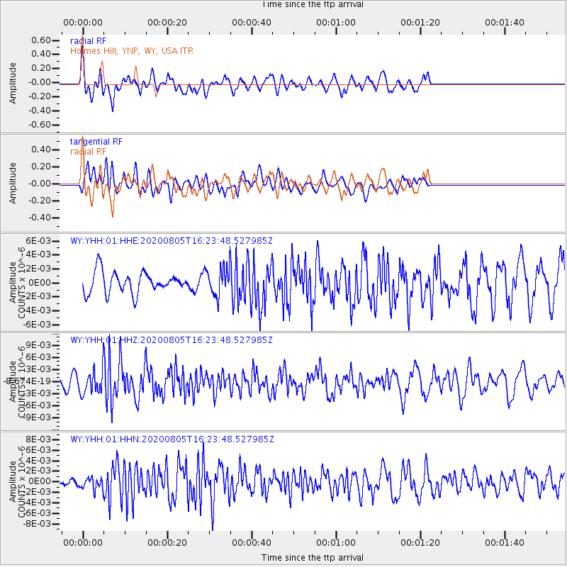
YHH Holmes Hill, YNP, WY, USA - Earthquake Result Viewer
*The percent match for this event was below the threshold and hence no stack was calculated.
| Earthquake location: |
Alaska Peninsula |
| Earthquake latitude/longitude: |
54.6/-161.2 |
| Earthquake time(UTC): |
2020/08/05 (218) 16:17:40 GMT |
| Earthquake Depth: |
4.8 km |
| Earthquake Magnitude: |
5.2 Mww |
| Earthquake Catalog/Contributor: |
NEIC PDE/us |
|
| Network: |
WY Yellowstone Wyoming Seismic Network |
| Station: |
YHH Holmes Hill, YNP, WY, USA |
| Lat/Lon: |
44.79 N/110.85 W |
| Elevation: |
2717 m |
|
| Distance: |
33.3 deg |
| Az: |
85.932 deg |
| Baz: |
305.404 deg |
| Ray Param: |
$rayparam |
*The percent match for this event was below the threshold and hence was not used in the summary stack. |
|
| Radial Match: |
58.988403 % |
| Radial Bump: |
400 |
| Transverse Match: |
59.749813 % |
| Transverse Bump: |
400 |
| SOD ConfigId: |
21709731 |
| Insert Time: |
2020-08-19 16:38:25.733 +0000 |
| GWidth: |
2.5 |
| Max Bumps: |
400 |
| Tol: |
0.001 |
|
Signal To Noise
| Channel | StoN | STA | LTA |
| WY:YHH:01:HHZ:20200805T16:23:48.527985Z | 2.8450508 | 2.780006E-9 | 9.771376E-10 |
| WY:YHH:01:HHN:20200805T16:23:48.527985Z | 1.5188583 | 1.0546277E-9 | 6.943556E-10 |
| WY:YHH:01:HHE:20200805T16:23:48.527985Z | 1.2825516 | 1.9204662E-9 | 1.4973792E-9 |
| Arrivals |
| Ps | |
| PpPs | |
| PsPs/PpSs | |


