You are here: Home > Network List > G - GEOSCOPE Stations List
> Station MBO M'Bour, Senegal > Earthquake Result Viewer
MBO M'Bour, Senegal - Earthquake Result Viewer
| Earthquake location: |
Dodecanese Islands, Greece |
| Earthquake latitude/longitude: |
36.9/27.5 |
| Earthquake time(UTC): |
2017/07/20 (201) 22:31:12 GMT |
| Earthquake Depth: |
10 km |
| Earthquake Magnitude: |
6.7 Mww |
| Earthquake Catalog/Contributor: |
NEIC PDE/us |
|
| Network: |
G GEOSCOPE |
| Station: |
MBO M'Bour, Senegal |
| Lat/Lon: |
14.39 N/16.95 W |
| Elevation: |
3.0 m |
|
| Distance: |
45.4 deg |
| Az: |
252.299 deg |
| Baz: |
51.96 deg |
| Ray Param: |
0.07131308 |
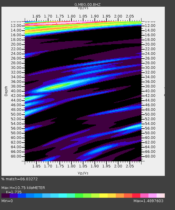
| Estimated Moho Depth: |
10.75 km |
| Estimated Crust Vp/Vs: |
1.74 |
| Assumed Crust Vp: |
5.55 km/s |
| Estimated Crust Vs: |
3.199 km/s |
| Estimated Crust Poisson's Ratio: |
0.25 |
|
| Radial Match: |
86.83272 % |
| Radial Bump: |
400 |
| Transverse Match: |
68.4402 % |
| Transverse Bump: |
400 |
| SOD ConfigId: |
2140511 |
| Insert Time: |
2017-08-03 14:32:43.022 +0000 |
| GWidth: |
2.5 |
| Max Bumps: |
400 |
| Tol: |
0.001 |
|
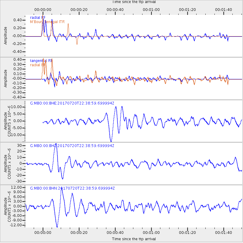
Signal To Noise
| Channel | StoN | STA | LTA |
| G:MBO:00:BHZ:20170720T22:38:59.699994Z | 5.302413 | 5.713696E-6 | 1.0775652E-6 |
| G:MBO:00:BHN:20170720T22:38:59.699994Z | 0.84439886 | 1.4530576E-6 | 1.720819E-6 |
| G:MBO:00:BHE:20170720T22:38:59.699994Z | 1.5909427 | 1.7454702E-6 | 1.0971295E-6 |
| Arrivals |
| Ps | 1.5 SECOND |
| PpPs | 5.1 SECOND |
| PsPs/PpSs | 6.5 SECOND |


