You are here: Home > Network List > GS - US Geological Survey Networks Stations List
> Station OK035 E0210 Rd and N2420 Rd, Alva, Oklahoma, USA > Earthquake Result Viewer
OK035 E0210 Rd and N2420 Rd, Alva, Oklahoma, USA - Earthquake Result Viewer
| Earthquake location: |
Dodecanese Islands, Greece |
| Earthquake latitude/longitude: |
36.9/27.5 |
| Earthquake time(UTC): |
2017/07/20 (201) 22:31:12 GMT |
| Earthquake Depth: |
10 km |
| Earthquake Magnitude: |
6.7 Mww |
| Earthquake Catalog/Contributor: |
NEIC PDE/us |
|
| Network: |
GS US Geological Survey Networks |
| Station: |
OK035 E0210 Rd and N2420 Rd, Alva, Oklahoma, USA |
| Lat/Lon: |
36.71 N/98.71 W |
| Elevation: |
485 m |
|
| Distance: |
91.4 deg |
| Az: |
319.539 deg |
| Baz: |
40.309 deg |
| Ray Param: |
0.04160771 |
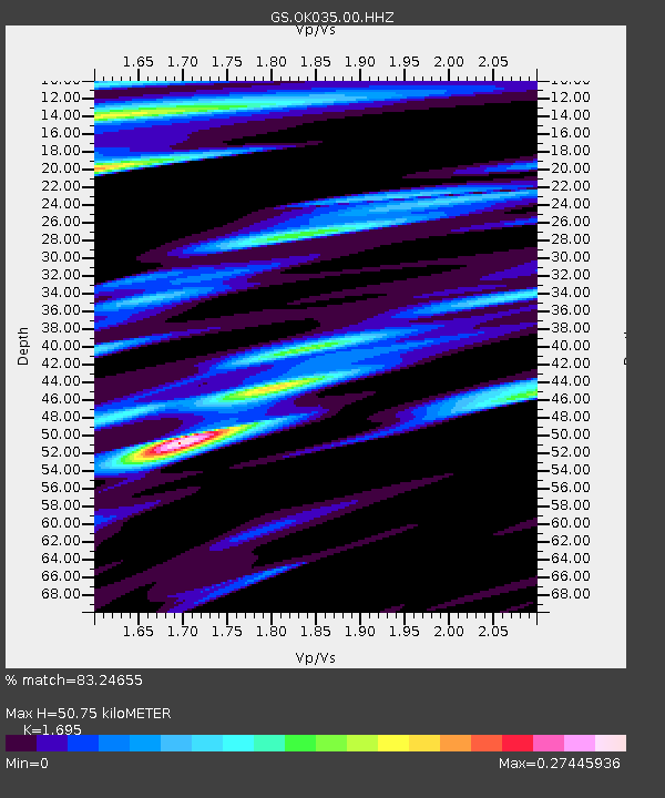
| Estimated Moho Depth: |
50.75 km |
| Estimated Crust Vp/Vs: |
1.70 |
| Assumed Crust Vp: |
6.426 km/s |
| Estimated Crust Vs: |
3.791 km/s |
| Estimated Crust Poisson's Ratio: |
0.23 |
|
| Radial Match: |
83.24655 % |
| Radial Bump: |
400 |
| Transverse Match: |
51.956013 % |
| Transverse Bump: |
400 |
| SOD ConfigId: |
2140511 |
| Insert Time: |
2017-08-03 14:34:58.976 +0000 |
| GWidth: |
2.5 |
| Max Bumps: |
400 |
| Tol: |
0.001 |
|

Signal To Noise
| Channel | StoN | STA | LTA |
| GS:OK035:00:HHZ:20170720T22:43:46.349011Z | 15.651922 | 1.9259917E-6 | 1.2305145E-7 |
| GS:OK035:00:HH1:20170720T22:43:46.349011Z | 1.413484 | 4.611166E-7 | 3.2622697E-7 |
| GS:OK035:00:HH2:20170720T22:43:46.349011Z | 1.8426337 | 4.833616E-7 | 2.6232104E-7 |
| Arrivals |
| Ps | 5.6 SECOND |
| PpPs | 21 SECOND |
| PsPs/PpSs | 26 SECOND |


