You are here: Home > Network List > GS - US Geological Survey Networks Stations List
> Station OK031 S. Brethren Rd., Cushing, OK, USA > Earthquake Result Viewer
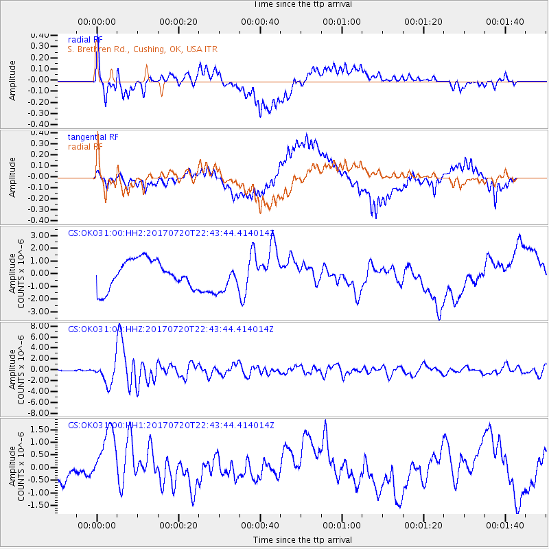
OK031 S. Brethren Rd., Cushing, OK, USA - Earthquake Result Viewer
*The percent match for this event was below the threshold and hence no stack was calculated.
| Earthquake location: |
Dodecanese Islands, Greece |
| Earthquake latitude/longitude: |
36.9/27.5 |
| Earthquake time(UTC): |
2017/07/20 (201) 22:31:12 GMT |
| Earthquake Depth: |
10 km |
| Earthquake Magnitude: |
6.7 Mww |
| Earthquake Catalog/Contributor: |
NEIC PDE/us |
|
| Network: |
GS US Geological Survey Networks |
| Station: |
OK031 S. Brethren Rd., Cushing, OK, USA |
| Lat/Lon: |
35.95 N/96.84 W |
| Elevation: |
290 m |
|
| Distance: |
90.9 deg |
| Az: |
317.903 deg |
| Baz: |
41.446 deg |
| Ray Param: |
$rayparam |
*The percent match for this event was below the threshold and hence was not used in the summary stack. |
|
| Radial Match: |
47.121044 % |
| Radial Bump: |
400 |
| Transverse Match: |
45.15322 % |
| Transverse Bump: |
400 |
| SOD ConfigId: |
2140511 |
| Insert Time: |
2017-08-03 14:35:26.102 +0000 |
| GWidth: |
2.5 |
| Max Bumps: |
400 |
| Tol: |
0.001 |
|
Signal To Noise
| Channel | StoN | STA | LTA |
| GS:OK031:00:HHZ:20170720T22:43:44.414014Z | 27.656738 | 2.0487557E-6 | 7.4077995E-8 |
| GS:OK031:00:HH1:20170720T22:43:44.414014Z | 2.0496652 | 1.5124243E-6 | 7.378885E-7 |
| GS:OK031:00:HH2:20170720T22:43:44.414014Z | 1.0207369 | 1.1186092E-6 | 1.095884E-6 |
| Arrivals |
| Ps | |
| PpPs | |
| PsPs/PpSs | |


