You are here: Home > Network List > IU - Global Seismograph Network (GSN - IRIS/USGS) Stations List
> Station CCM Cathedral Cave, Missouri, USA > Earthquake Result Viewer
CCM Cathedral Cave, Missouri, USA - Earthquake Result Viewer

| Earthquake location: |
Dodecanese Islands, Greece |
| Earthquake latitude/longitude: |
36.9/27.5 |
| Earthquake time(UTC): |
2017/07/20 (201) 22:31:12 GMT |
| Earthquake Depth: |
10 km |
| Earthquake Magnitude: |
6.7 Mww |
| Earthquake Catalog/Contributor: |
NEIC PDE/us |
|
| Network: |
IU Global Seismograph Network (GSN - IRIS/USGS) |
| Station: |
CCM Cathedral Cave, Missouri, USA |
| Lat/Lon: |
38.06 N/91.24 W |
| Elevation: |
222 m |
|
| Distance: |
86.3 deg |
| Az: |
316.066 deg |
| Baz: |
44.757 deg |
| Ray Param: |
0.04411545 |
| Estimated Moho Depth: |
45.25 km |
| Estimated Crust Vp/Vs: |
1.82 |
| Assumed Crust Vp: |
6.498 km/s |
| Estimated Crust Vs: |
3.58 km/s |
| Estimated Crust Poisson's Ratio: |
0.28 |
|
| Radial Match: |
97.39264 % |
| Radial Bump: |
331 |
| Transverse Match: |
97.69195 % |
| Transverse Bump: |
353 |
| SOD ConfigId: |
2140511 |
| Insert Time: |
2017-08-03 14:37:01.842 +0000 |
| GWidth: |
2.5 |
| Max Bumps: |
400 |
| Tol: |
0.001 |
|
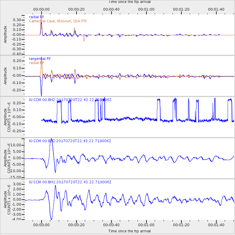
Signal To Noise
| Channel | StoN | STA | LTA |
| IU:CCM:00:BHZ:20170720T22:43:22.719006Z | 92.86279 | 3.7854406E-6 | 4.0763805E-8 |
| IU:CCM:00:BH1:20170720T22:43:22.719006Z | 20.379324 | 9.5147317E-7 | 4.668816E-8 |
| IU:CCM:00:BH2:20170720T22:43:22.719006Z | 1.4266706 | 1.4530956E-7 | 1.0185222E-7 |
| Arrivals |
| Ps | 5.8 SECOND |
| PpPs | 19 SECOND |
| PsPs/PpSs | 25 SECOND |


