You are here: Home > Network List > IW - Intermountain West Stations List
> Station DLMT Dillon, Montana, USA > Earthquake Result Viewer
DLMT Dillon, Montana, USA - Earthquake Result Viewer
| Earthquake location: |
Dodecanese Islands, Greece |
| Earthquake latitude/longitude: |
36.9/27.5 |
| Earthquake time(UTC): |
2017/07/20 (201) 22:31:12 GMT |
| Earthquake Depth: |
10 km |
| Earthquake Magnitude: |
6.7 Mww |
| Earthquake Catalog/Contributor: |
NEIC PDE/us |
|
| Network: |
IW Intermountain West |
| Station: |
DLMT Dillon, Montana, USA |
| Lat/Lon: |
45.36 N/112.60 W |
| Elevation: |
1569 m |
|
| Distance: |
90.5 deg |
| Az: |
333.085 deg |
| Baz: |
30.956 deg |
| Ray Param: |
0.041669782 |
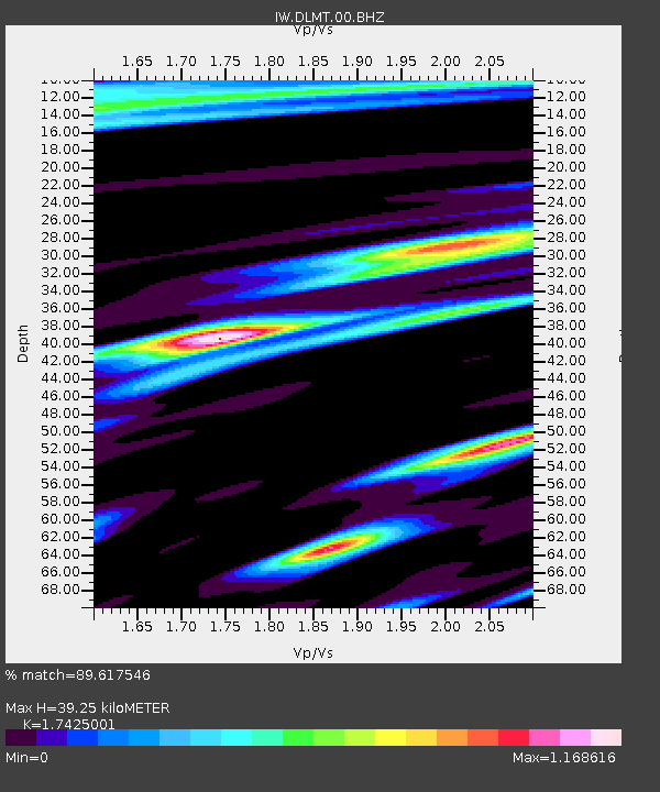
| Estimated Moho Depth: |
39.25 km |
| Estimated Crust Vp/Vs: |
1.74 |
| Assumed Crust Vp: |
6.577 km/s |
| Estimated Crust Vs: |
3.774 km/s |
| Estimated Crust Poisson's Ratio: |
0.25 |
|
| Radial Match: |
89.617546 % |
| Radial Bump: |
400 |
| Transverse Match: |
87.47261 % |
| Transverse Bump: |
400 |
| SOD ConfigId: |
2140511 |
| Insert Time: |
2017-08-03 14:38:40.440 +0000 |
| GWidth: |
2.5 |
| Max Bumps: |
400 |
| Tol: |
0.001 |
|
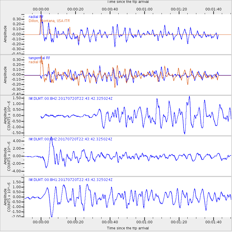
Signal To Noise
| Channel | StoN | STA | LTA |
| IW:DLMT:00:BHZ:20170720T22:43:42.325024Z | 18.900846 | 1.4438226E-6 | 7.6389306E-8 |
| IW:DLMT:00:BH1:20170720T22:43:42.325024Z | 7.0061803 | 5.026321E-7 | 7.174124E-8 |
| IW:DLMT:00:BH2:20170720T22:43:42.325024Z | 4.3652587 | 2.8495145E-7 | 6.5277106E-8 |
| Arrivals |
| Ps | 4.5 SECOND |
| PpPs | 16 SECOND |
| PsPs/PpSs | 21 SECOND |


