You are here: Home > Network List > NM - Cooperative New Madrid Seismic Network Stations List
> Station HENM Henderson Mound,MO > Earthquake Result Viewer
HENM Henderson Mound,MO - Earthquake Result Viewer
| Earthquake location: |
Dodecanese Islands, Greece |
| Earthquake latitude/longitude: |
36.9/27.5 |
| Earthquake time(UTC): |
2017/07/20 (201) 22:31:12 GMT |
| Earthquake Depth: |
10 km |
| Earthquake Magnitude: |
6.7 Mww |
| Earthquake Catalog/Contributor: |
NEIC PDE/us |
|
| Network: |
NM Cooperative New Madrid Seismic Network |
| Station: |
HENM Henderson Mound,MO |
| Lat/Lon: |
36.72 N/89.47 W |
| Elevation: |
88 m |
|
| Distance: |
86.3 deg |
| Az: |
314.119 deg |
| Baz: |
45.704 deg |
| Ray Param: |
0.044158503 |
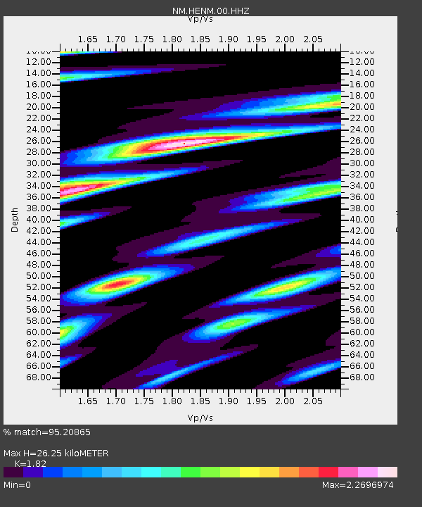
| Estimated Moho Depth: |
26.25 km |
| Estimated Crust Vp/Vs: |
1.82 |
| Assumed Crust Vp: |
6.444 km/s |
| Estimated Crust Vs: |
3.541 km/s |
| Estimated Crust Poisson's Ratio: |
0.28 |
|
| Radial Match: |
95.20865 % |
| Radial Bump: |
400 |
| Transverse Match: |
78.47434 % |
| Transverse Bump: |
400 |
| SOD ConfigId: |
2140511 |
| Insert Time: |
2017-08-03 14:40:38.418 +0000 |
| GWidth: |
2.5 |
| Max Bumps: |
400 |
| Tol: |
0.001 |
|

Signal To Noise
| Channel | StoN | STA | LTA |
| NM:HENM:00:HHZ:20170720T22:43:22.425Z | 14.905757 | 5.4655097E-6 | 3.6667106E-7 |
| NM:HENM:00:HHN:20170720T22:43:22.425Z | 3.3126018 | 1.2796737E-6 | 3.8630475E-7 |
| NM:HENM:00:HHE:20170720T22:43:22.425Z | 4.7412605 | 1.9067186E-6 | 4.0215437E-7 |
| Arrivals |
| Ps | 3.4 SECOND |
| PpPs | 11 SECOND |
| PsPs/PpSs | 15 SECOND |


