You are here: Home > Network List > NM - Cooperative New Madrid Seismic Network Stations List
> Station UTMT Martin, TN > Earthquake Result Viewer
UTMT Martin, TN - Earthquake Result Viewer
| Earthquake location: |
Dodecanese Islands, Greece |
| Earthquake latitude/longitude: |
36.9/27.5 |
| Earthquake time(UTC): |
2017/07/20 (201) 22:31:12 GMT |
| Earthquake Depth: |
10 km |
| Earthquake Magnitude: |
6.7 Mww |
| Earthquake Catalog/Contributor: |
NEIC PDE/us |
|
| Network: |
NM Cooperative New Madrid Seismic Network |
| Station: |
UTMT Martin, TN |
| Lat/Lon: |
36.35 N/88.86 W |
| Elevation: |
110 m |
|
| Distance: |
86.2 deg |
| Az: |
313.514 deg |
| Baz: |
46.025 deg |
| Ray Param: |
0.0442274 |
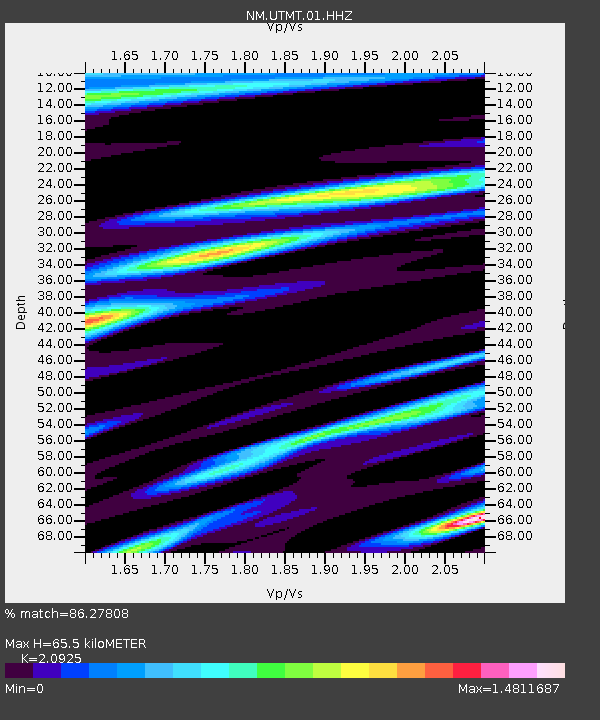
| Estimated Moho Depth: |
65.5 km |
| Estimated Crust Vp/Vs: |
2.09 |
| Assumed Crust Vp: |
6.444 km/s |
| Estimated Crust Vs: |
3.08 km/s |
| Estimated Crust Poisson's Ratio: |
0.35 |
|
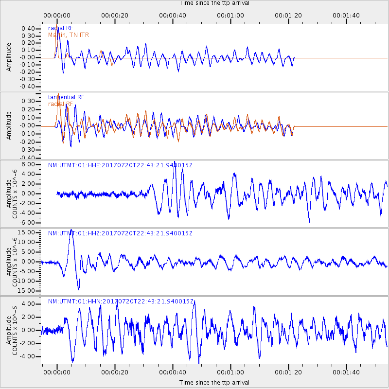
| Radial Match: |
86.27808 % |
| Radial Bump: |
400 |
| Transverse Match: |
74.51862 % |
| Transverse Bump: |
400 |
| SOD ConfigId: |
2140511 |
| Insert Time: |
2017-08-03 14:41:09.815 +0000 |
| GWidth: |
2.5 |
| Max Bumps: |
400 |
| Tol: |
0.001 |
|
Signal To Noise
| Channel | StoN | STA | LTA |
| NM:UTMT:01:HHZ:20170720T22:43:21.940015Z | 23.147795 | 5.9162317E-6 | 2.5558512E-7 |
| NM:UTMT:01:HHN:20170720T22:43:21.940015Z | 3.3281217 | 1.0723182E-6 | 3.2219924E-7 |
| NM:UTMT:01:HHE:20170720T22:43:21.940015Z | 3.9043627 | 1.2274494E-6 | 3.1437892E-7 |
| Arrivals |
| Ps | 11 SECOND |
| PpPs | 31 SECOND |
| PsPs/PpSs | 42 SECOND |


