You are here: Home > Network List > TA - USArray Transportable Network (new EarthScope stations) Stations List
> Station R33M Jennings River, BC, CAN > Earthquake Result Viewer
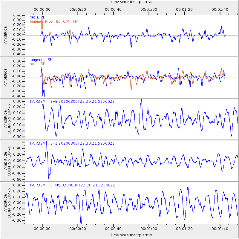
R33M Jennings River, BC, CAN - Earthquake Result Viewer
*The percent match for this event was below the threshold and hence no stack was calculated.
| Earthquake location: |
Near Coast Of Peru |
| Earthquake latitude/longitude: |
-15.9/-74.9 |
| Earthquake time(UTC): |
2020/08/06 (219) 22:18:04 GMT |
| Earthquake Depth: |
10 km |
| Earthquake Magnitude: |
5.5 Mww |
| Earthquake Catalog/Contributor: |
NEIC PDE/us |
|
| Network: |
TA USArray Transportable Network (new EarthScope stations) |
| Station: |
R33M Jennings River, BC, CAN |
| Lat/Lon: |
59.39 N/130.97 W |
| Elevation: |
1437 m |
|
| Distance: |
87.6 deg |
| Az: |
334.848 deg |
| Baz: |
126.925 deg |
| Ray Param: |
$rayparam |
*The percent match for this event was below the threshold and hence was not used in the summary stack. |
|
| Radial Match: |
38.51873 % |
| Radial Bump: |
400 |
| Transverse Match: |
75.758316 % |
| Transverse Bump: |
400 |
| SOD ConfigId: |
21709731 |
| Insert Time: |
2020-08-20 22:38:44.290 +0000 |
| GWidth: |
2.5 |
| Max Bumps: |
400 |
| Tol: |
0.001 |
|
Signal To Noise
| Channel | StoN | STA | LTA |
| TA:R33M: :BHZ:20200806T22:30:21.525002Z | 2.6844504 | 3.0405388E-7 | 1.13264846E-7 |
| TA:R33M: :BHN:20200806T22:30:21.525002Z | 1.0740254 | 1.1167156E-7 | 1.0397479E-7 |
| TA:R33M: :BHE:20200806T22:30:21.525002Z | 0.6757612 | 8.504401E-8 | 1.258492E-7 |
| Arrivals |
| Ps | |
| PpPs | |
| PsPs/PpSs | |


