You are here: Home > Network List > US - United States National Seismic Network Stations List
> Station AMTX Amarillo, Texas, USA > Earthquake Result Viewer
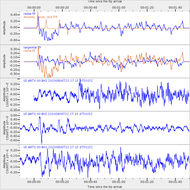
AMTX Amarillo, Texas, USA - Earthquake Result Viewer
*The percent match for this event was below the threshold and hence no stack was calculated.
| Earthquake location: |
Near Coast Of Peru |
| Earthquake latitude/longitude: |
-15.9/-74.9 |
| Earthquake time(UTC): |
2020/08/06 (219) 22:18:04 GMT |
| Earthquake Depth: |
10 km |
| Earthquake Magnitude: |
5.5 Mww |
| Earthquake Catalog/Contributor: |
NEIC PDE/us |
|
| Network: |
US United States National Seismic Network |
| Station: |
AMTX Amarillo, Texas, USA |
| Lat/Lon: |
34.53 N/101.41 W |
| Elevation: |
1010 m |
|
| Distance: |
56.1 deg |
| Az: |
333.62 deg |
| Baz: |
148.807 deg |
| Ray Param: |
$rayparam |
*The percent match for this event was below the threshold and hence was not used in the summary stack. |
|
| Radial Match: |
64.364845 % |
| Radial Bump: |
400 |
| Transverse Match: |
56.315567 % |
| Transverse Bump: |
400 |
| SOD ConfigId: |
21709731 |
| Insert Time: |
2020-08-20 22:41:04.304 +0000 |
| GWidth: |
2.5 |
| Max Bumps: |
400 |
| Tol: |
0.001 |
|
Signal To Noise
| Channel | StoN | STA | LTA |
| US:AMTX:00:BHZ:20200806T22:27:15.975015Z | 3.1164076 | 2.1534845E-7 | 6.91015E-8 |
| US:AMTX:00:BH1:20200806T22:27:15.975015Z | 1.1542574 | 6.4747624E-8 | 5.6094617E-8 |
| US:AMTX:00:BH2:20200806T22:27:15.975015Z | 1.0800571 | 6.143586E-8 | 5.6882048E-8 |
| Arrivals |
| Ps | |
| PpPs | |
| PsPs/PpSs | |


