You are here: Home > Network List > US - United States National Seismic Network Stations List
> Station DGMT Dagmar, Montana, USA > Earthquake Result Viewer
DGMT Dagmar, Montana, USA - Earthquake Result Viewer
*The percent match for this event was below the threshold and hence no stack was calculated.
| Earthquake location: |
Near Coast Of Peru |
| Earthquake latitude/longitude: |
-15.9/-74.9 |
| Earthquake time(UTC): |
2020/08/06 (219) 22:18:04 GMT |
| Earthquake Depth: |
10 km |
| Earthquake Magnitude: |
5.5 Mww |
| Earthquake Catalog/Contributor: |
NEIC PDE/us |
|
| Network: |
US United States National Seismic Network |
| Station: |
DGMT Dagmar, Montana, USA |
| Lat/Lon: |
48.47 N/104.20 W |
| Elevation: |
0.0 m |
|
| Distance: |
69.2 deg |
| Az: |
339.591 deg |
| Baz: |
149.716 deg |
| Ray Param: |
$rayparam |
*The percent match for this event was below the threshold and hence was not used in the summary stack. |
|
| Radial Match: |
50.80897 % |
| Radial Bump: |
400 |
| Transverse Match: |
56.40807 % |
| Transverse Bump: |
400 |
| SOD ConfigId: |
21709731 |
| Insert Time: |
2020-08-20 22:41:15.121 +0000 |
| GWidth: |
2.5 |
| Max Bumps: |
400 |
| Tol: |
0.001 |
|
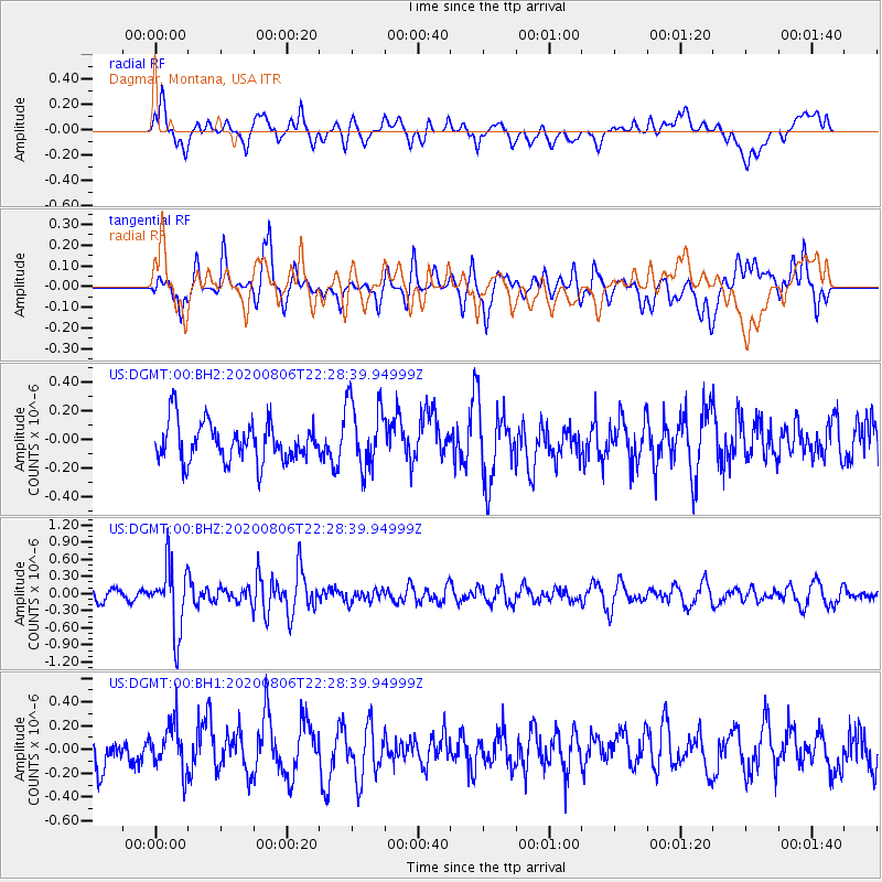
Signal To Noise
| Channel | StoN | STA | LTA |
| US:DGMT:00:BHZ:20200806T22:28:39.94999Z | 5.505687 | 5.8482647E-7 | 1.0622225E-7 |
| US:DGMT:00:BH1:20200806T22:28:39.94999Z | 1.412474 | 1.9748163E-7 | 1.3981257E-7 |
| US:DGMT:00:BH2:20200806T22:28:39.94999Z | 1.7685834 | 2.3817854E-7 | 1.3467194E-7 |
| Arrivals |
| Ps | |
| PpPs | |
| PsPs/PpSs | |


