You are here: Home > Network List > US - United States National Seismic Network Stations List
> Station HAWA Hanford, Washington, USA > Earthquake Result Viewer
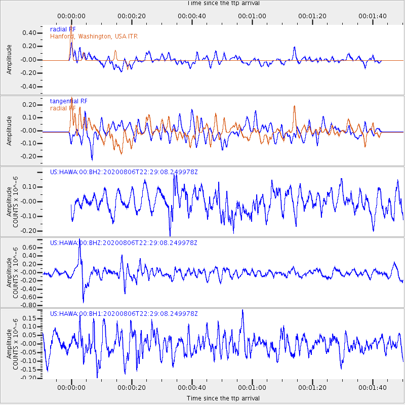
HAWA Hanford, Washington, USA - Earthquake Result Viewer
*The percent match for this event was below the threshold and hence no stack was calculated.
| Earthquake location: |
Near Coast Of Peru |
| Earthquake latitude/longitude: |
-15.9/-74.9 |
| Earthquake time(UTC): |
2020/08/06 (219) 22:18:04 GMT |
| Earthquake Depth: |
10 km |
| Earthquake Magnitude: |
5.5 Mww |
| Earthquake Catalog/Contributor: |
NEIC PDE/us |
|
| Network: |
US United States National Seismic Network |
| Station: |
HAWA Hanford, Washington, USA |
| Lat/Lon: |
46.39 N/119.53 W |
| Elevation: |
364 m |
|
| Distance: |
73.9 deg |
| Az: |
329.574 deg |
| Baz: |
135.239 deg |
| Ray Param: |
$rayparam |
*The percent match for this event was below the threshold and hence was not used in the summary stack. |
|
| Radial Match: |
57.106632 % |
| Radial Bump: |
400 |
| Transverse Match: |
54.603844 % |
| Transverse Bump: |
400 |
| SOD ConfigId: |
21709731 |
| Insert Time: |
2020-08-20 22:41:26.134 +0000 |
| GWidth: |
2.5 |
| Max Bumps: |
400 |
| Tol: |
0.001 |
|
Signal To Noise
| Channel | StoN | STA | LTA |
| US:HAWA:00:BHZ:20200806T22:29:08.249978Z | 5.0470843 | 3.358132E-7 | 6.653608E-8 |
| US:HAWA:00:BH1:20200806T22:29:08.249978Z | 0.8668102 | 5.5938163E-8 | 6.4533346E-8 |
| US:HAWA:00:BH2:20200806T22:29:08.249978Z | 1.6011945 | 9.537193E-8 | 5.956299E-8 |
| Arrivals |
| Ps | |
| PpPs | |
| PsPs/PpSs | |


