You are here: Home > Network List > UW - Pacific Northwest Regional Seismic Network Stations List
> Station IRON Crane, OR, USA > Earthquake Result Viewer
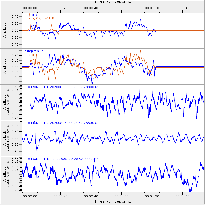
IRON Crane, OR, USA - Earthquake Result Viewer
*The percent match for this event was below the threshold and hence no stack was calculated.
| Earthquake location: |
Near Coast Of Peru |
| Earthquake latitude/longitude: |
-15.9/-74.9 |
| Earthquake time(UTC): |
2020/08/06 (219) 22:18:04 GMT |
| Earthquake Depth: |
10 km |
| Earthquake Magnitude: |
5.5 Mww |
| Earthquake Catalog/Contributor: |
NEIC PDE/us |
|
| Network: |
UW Pacific Northwest Regional Seismic Network |
| Station: |
IRON Crane, OR, USA |
| Lat/Lon: |
43.36 N/118.47 W |
| Elevation: |
1226 m |
|
| Distance: |
71.2 deg |
| Az: |
327.9 deg |
| Baz: |
135.481 deg |
| Ray Param: |
$rayparam |
*The percent match for this event was below the threshold and hence was not used in the summary stack. |
|
| Radial Match: |
49.912315 % |
| Radial Bump: |
400 |
| Transverse Match: |
47.12346 % |
| Transverse Bump: |
400 |
| SOD ConfigId: |
21709731 |
| Insert Time: |
2020-08-20 22:43:24.980 +0000 |
| GWidth: |
2.5 |
| Max Bumps: |
400 |
| Tol: |
0.001 |
|
Signal To Noise
| Channel | StoN | STA | LTA |
| UW:IRON: :HHZ:20200806T22:28:52.288003Z | 4.510834 | 2.646582E-7 | 5.8671674E-8 |
| UW:IRON: :HHN:20200806T22:28:52.288003Z | 1.5317074 | 6.842578E-8 | 4.4672877E-8 |
| UW:IRON: :HHE:20200806T22:28:52.288003Z | 1.4159524 | 6.864852E-8 | 4.848222E-8 |
| Arrivals |
| Ps | |
| PpPs | |
| PsPs/PpSs | |


