You are here: Home > Network List > TJ - Tajikistan National Seismic Network Stations List
> Station GARM Garm, Tajikistan > Earthquake Result Viewer
GARM Garm, Tajikistan - Earthquake Result Viewer
| Earthquake location: |
Prince Edward Islands Region |
| Earthquake latitude/longitude: |
-41.7/42.4 |
| Earthquake time(UTC): |
2020/08/06 (219) 23:36:44 GMT |
| Earthquake Depth: |
10 km |
| Earthquake Magnitude: |
6.3 mww |
| Earthquake Catalog/Contributor: |
NEIC PDE/us |
|
| Network: |
TJ Tajikistan National Seismic Network |
| Station: |
GARM Garm, Tajikistan |
| Lat/Lon: |
39.00 N/70.32 E |
| Elevation: |
1305 m |
|
| Distance: |
84.3 deg |
| Az: |
21.521 deg |
| Baz: |
200.628 deg |
| Ray Param: |
0.045585476 |
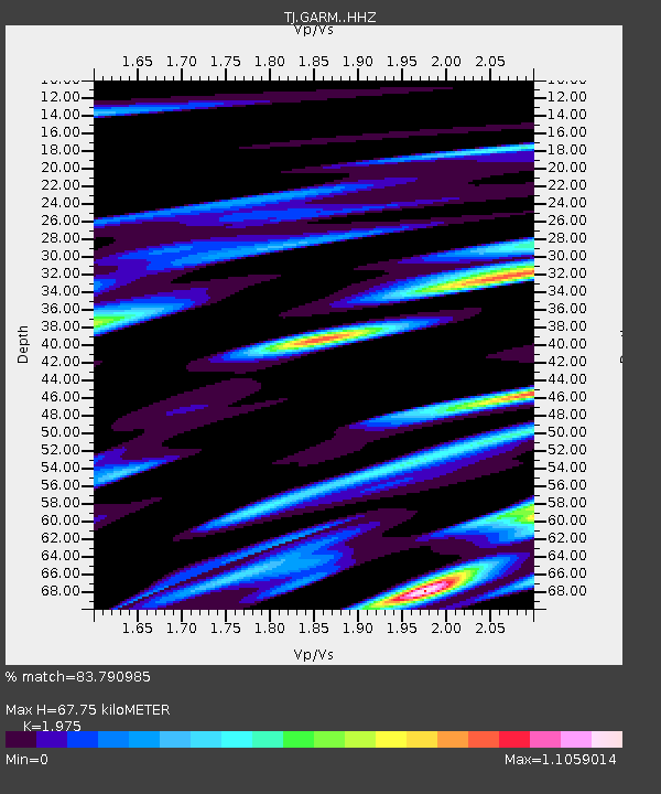
| Estimated Moho Depth: |
67.75 km |
| Estimated Crust Vp/Vs: |
1.98 |
| Assumed Crust Vp: |
6.306 km/s |
| Estimated Crust Vs: |
3.193 km/s |
| Estimated Crust Poisson's Ratio: |
0.33 |
|
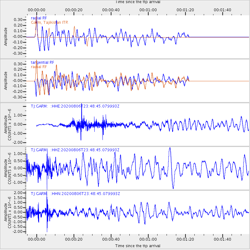
| Radial Match: |
83.790985 % |
| Radial Bump: |
400 |
| Transverse Match: |
57.286938 % |
| Transverse Bump: |
400 |
| SOD ConfigId: |
21709731 |
| Insert Time: |
2020-08-20 23:41:15.572 +0000 |
| GWidth: |
2.5 |
| Max Bumps: |
400 |
| Tol: |
0.001 |
|
Signal To Noise
| Channel | StoN | STA | LTA |
| TJ:GARM: :HHZ:20200806T23:48:45.079993Z | 1.0856445 | 2.86776E-7 | 2.6415276E-7 |
| TJ:GARM: :HHN:20200806T23:48:45.079993Z | 0.7422474 | 2.735116E-7 | 3.684912E-7 |
| TJ:GARM: :HHE:20200806T23:48:45.079993Z | 0.9099509 | 2.2140262E-7 | 2.433127E-7 |
| Arrivals |
| Ps | 11 SECOND |
| PpPs | 31 SECOND |
| PsPs/PpSs | 42 SECOND |


