You are here: Home > Network List > US - United States National Seismic Network Stations List
> Station GLMI Grayling, Michigan, USA > Earthquake Result Viewer
GLMI Grayling, Michigan, USA - Earthquake Result Viewer
| Earthquake location: |
Dodecanese Islands, Greece |
| Earthquake latitude/longitude: |
36.9/27.5 |
| Earthquake time(UTC): |
2017/07/20 (201) 22:31:12 GMT |
| Earthquake Depth: |
10 km |
| Earthquake Magnitude: |
6.7 Mww |
| Earthquake Catalog/Contributor: |
NEIC PDE/us |
|
| Network: |
US United States National Seismic Network |
| Station: |
GLMI Grayling, Michigan, USA |
| Lat/Lon: |
44.82 N/84.62 W |
| Elevation: |
387 m |
|
| Distance: |
78.1 deg |
| Az: |
317.627 deg |
| Baz: |
49.349 deg |
| Ray Param: |
0.04987298 |
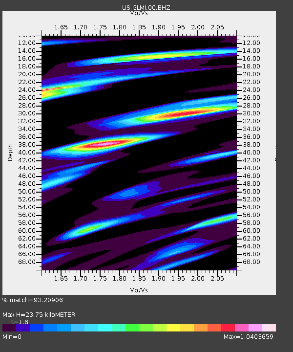
| Estimated Moho Depth: |
23.75 km |
| Estimated Crust Vp/Vs: |
1.60 |
| Assumed Crust Vp: |
6.483 km/s |
| Estimated Crust Vs: |
4.052 km/s |
| Estimated Crust Poisson's Ratio: |
0.18 |
|
| Radial Match: |
93.20906 % |
| Radial Bump: |
400 |
| Transverse Match: |
81.39268 % |
| Transverse Bump: |
400 |
| SOD ConfigId: |
2140511 |
| Insert Time: |
2017-08-03 14:43:04.542 +0000 |
| GWidth: |
2.5 |
| Max Bumps: |
400 |
| Tol: |
0.001 |
|

Signal To Noise
| Channel | StoN | STA | LTA |
| US:GLMI:00:BHZ:20170720T22:42:39.675Z | 26.111164 | 3.4819734E-6 | 1.333519E-7 |
| US:GLMI:00:BH1:20170720T22:42:39.675Z | 3.32836 | 9.0575935E-7 | 2.7213383E-7 |
| US:GLMI:00:BH2:20170720T22:42:39.675Z | 4.254729 | 1.0956694E-6 | 2.5751802E-7 |
| Arrivals |
| Ps | 2.3 SECOND |
| PpPs | 9.2 SECOND |
| PsPs/PpSs | 11 SECOND |


