You are here: Home > Network List > AU - Australian Seismological Centre Stations List
> Station CTA Charters Towers, Queensland > Earthquake Result Viewer
CTA Charters Towers, Queensland - Earthquake Result Viewer
| Earthquake location: |
Tonga Islands |
| Earthquake latitude/longitude: |
-16.2/-173.5 |
| Earthquake time(UTC): |
2009/10/02 (275) 01:09:26 GMT |
| Earthquake Depth: |
10 km |
| Earthquake Magnitude: |
5.5 MB |
| Earthquake Catalog/Contributor: |
WHDF/NEIC |
|
| Network: |
AU Australian Seismological Centre |
| Station: |
CTA Charters Towers, Queensland |
| Lat/Lon: |
20.09 S/146.25 E |
| Elevation: |
426 m |
|
| Distance: |
38.4 deg |
| Az: |
258.051 deg |
| Baz: |
91.027 deg |
| Ray Param: |
0.07558342 |
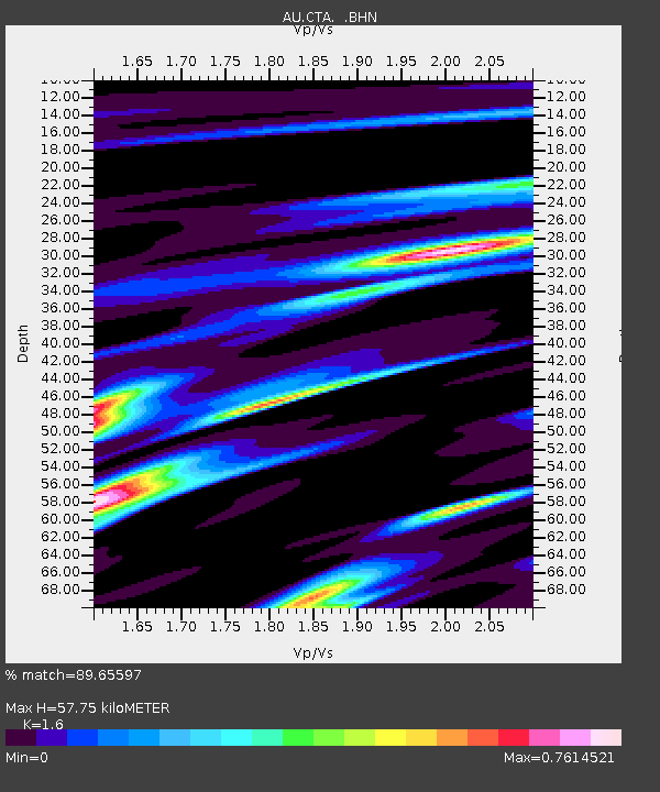
| Estimated Moho Depth: |
57.75 km |
| Estimated Crust Vp/Vs: |
1.60 |
| Assumed Crust Vp: |
6.522 km/s |
| Estimated Crust Vs: |
4.076 km/s |
| Estimated Crust Poisson's Ratio: |
0.18 |
|
| Radial Match: |
89.65597 % |
| Radial Bump: |
339 |
| Transverse Match: |
70.337975 % |
| Transverse Bump: |
400 |
| SOD ConfigId: |
2622 |
| Insert Time: |
2010-03-08 23:47:56.158 +0000 |
| GWidth: |
2.5 |
| Max Bumps: |
400 |
| Tol: |
0.001 |
|

Signal To Noise
| Channel | StoN | STA | LTA |
| AU:CTA: :BHN:20091002T01:16:17.248988Z | 1.0779467 | 9.997576E-7 | 9.274648E-7 |
| AU:CTA: :BHE:20091002T01:16:17.248988Z | 0.91386294 | 3.0645768E-7 | 3.3534315E-7 |
| AU:CTA: :BHZ:20091002T01:16:17.248988Z | 2.0719109 | 1.6155354E-6 | 7.797321E-7 |
| Arrivals |
| Ps | 5.8 SECOND |
| PpPs | 21 SECOND |
| PsPs/PpSs | 27 SECOND |


