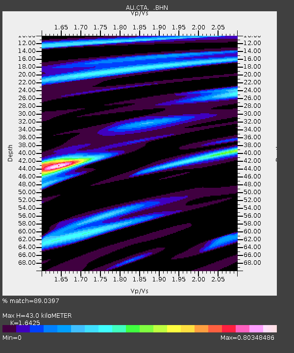
CTA Charters Towers, Queensland - Earthquake Result Viewer

Earthquake location: Southern Sumatra, Indonesia
Earthquake latitude/longitude: -4.7/101.8
Earthquake time(UTC): 2008/11/28 (333) 08:50:48 GMT
Earthquake Depth: 27 km
Earthquake Magnitude: 5.7 MB, 5.9 MS, 5.8 MW, 5.8 MW
Earthquake Catalog/Contributor: WHDF/NEIC
Network: AU Australian Seismological Centre
Station: CTA Charters Towers, Queensland
Lat/Lon: 20.09 S/146.25 E
Elevation: 426 m
Distance: 45.9 deg
Az: 113.416 deg
Baz: 283.339 deg
Ray Param: 0.07094397
Estimated Moho Depth: 43.0 km
Estimated Crust Vp/Vs: 1.64
Assumed Crust Vp: 6.522 km/s
Estimated Crust Vs: 3.971 km/s
Estimated Crust Poisson's Ratio: 0.21
Radial Match: 89.0397 %
Radial Bump: 313
Transverse Match: 70.28944 %
Transverse Bump: 400
SOD ConfigId: 2658
Insert Time: 2010-03-08 23:48:14.977 +0000
GWidth: 2.5
Max Bumps: 400
Tol: 0.001

Signal To Noise

ChannelStoNSTALTA
AU:CTA: :BHN:20081128T08:58:37.45001Z6.5127949.909754E-71.5215826E-7
AU:CTA: :BHE:20081128T08:58:37.45001Z2.16176221.6089503E-77.442772E-8
AU:CTA: :BHZ:20081128T08:58:37.45001Z6.3651745.838328E-79.1722995E-8
Arrivals
Ps4.5 SECOND
PpPs16 SECOND
PsPs/PpSs21 SECOND