You are here: Home > Network List > AU - Australian Seismological Centre Stations List
> Station CTA Charters Towers, Queensland > Earthquake Result Viewer
CTA Charters Towers, Queensland - Earthquake Result Viewer
| Earthquake location: |
Southeast Indian Ridge |
| Earthquake latitude/longitude: |
-53.0/106.8 |
| Earthquake time(UTC): |
2008/12/08 (343) 18:39:09 GMT |
| Earthquake Depth: |
10 km |
| Earthquake Magnitude: |
6.2 MB, 5.9 MS, 6.3 MW, 6.3 MW |
| Earthquake Catalog/Contributor: |
WHDF/NEIC |
|
| Network: |
AU Australian Seismological Centre |
| Station: |
CTA Charters Towers, Queensland |
| Lat/Lon: |
20.09 S/146.25 E |
| Elevation: |
426 m |
|
| Distance: |
44.7 deg |
| Az: |
58.061 deg |
| Baz: |
213.068 deg |
| Ray Param: |
0.07175479 |
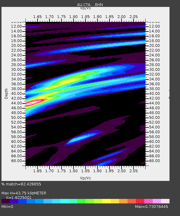
| Estimated Moho Depth: |
43.75 km |
| Estimated Crust Vp/Vs: |
1.62 |
| Assumed Crust Vp: |
6.522 km/s |
| Estimated Crust Vs: |
4.019 km/s |
| Estimated Crust Poisson's Ratio: |
0.19 |
|
| Radial Match: |
92.429855 % |
| Radial Bump: |
261 |
| Transverse Match: |
66.690575 % |
| Transverse Bump: |
400 |
| SOD ConfigId: |
2658 |
| Insert Time: |
2010-03-08 23:48:18.013 +0000 |
| GWidth: |
2.5 |
| Max Bumps: |
400 |
| Tol: |
0.001 |
|

Signal To Noise
| Channel | StoN | STA | LTA |
| AU:CTA: :BHN:20081208T18:46:51.500002Z | 17.90727 | 1.8819253E-6 | 1.050928E-7 |
| AU:CTA: :BHE:20081208T18:46:51.500002Z | 10.947908 | 8.3101526E-7 | 7.59063E-8 |
| AU:CTA: :BHZ:20081208T18:46:51.500002Z | 6.7107315 | 7.1377855E-7 | 1.0636375E-7 |
| Arrivals |
| Ps | 4.5 SECOND |
| PpPs | 16 SECOND |
| PsPs/PpSs | 21 SECOND |


