You are here: Home > Network List > AU - Australian Seismological Centre Stations List
> Station CTA Charters Towers, Queensland > Earthquake Result Viewer
CTA Charters Towers, Queensland - Earthquake Result Viewer
| Earthquake location: |
Kermadec Islands Region |
| Earthquake latitude/longitude: |
-31.2/-176.9 |
| Earthquake time(UTC): |
2008/12/09 (344) 06:23:59 GMT |
| Earthquake Depth: |
18 km |
| Earthquake Magnitude: |
6.2 MB, 6.7 MS, 6.8 MW, 6.7 MW |
| Earthquake Catalog/Contributor: |
WHDF/NEIC |
|
| Network: |
AU Australian Seismological Centre |
| Station: |
CTA Charters Towers, Queensland |
| Lat/Lon: |
20.09 S/146.25 E |
| Elevation: |
426 m |
|
| Distance: |
34.9 deg |
| Az: |
279.643 deg |
| Baz: |
116.038 deg |
| Ray Param: |
0.0775094 |
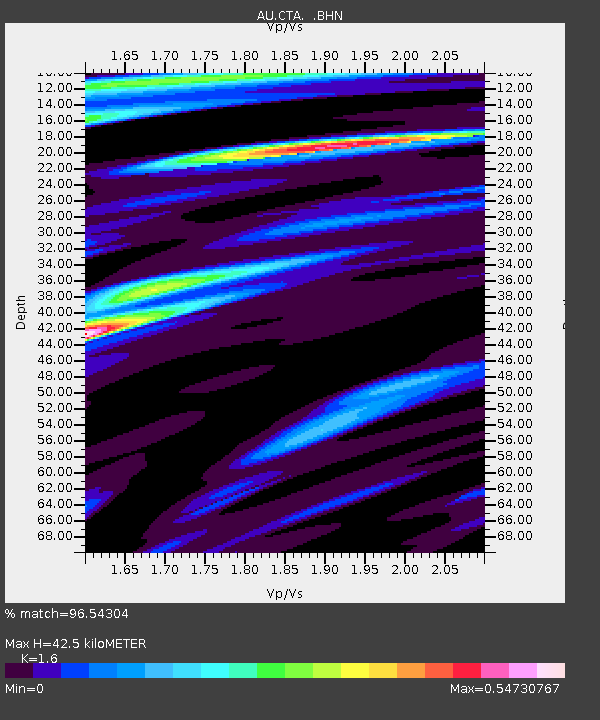
| Estimated Moho Depth: |
42.5 km |
| Estimated Crust Vp/Vs: |
1.60 |
| Assumed Crust Vp: |
6.522 km/s |
| Estimated Crust Vs: |
4.076 km/s |
| Estimated Crust Poisson's Ratio: |
0.18 |
|
| Radial Match: |
96.54304 % |
| Radial Bump: |
246 |
| Transverse Match: |
76.45464 % |
| Transverse Bump: |
400 |
| SOD ConfigId: |
2658 |
| Insert Time: |
2010-03-08 23:48:19.751 +0000 |
| GWidth: |
2.5 |
| Max Bumps: |
400 |
| Tol: |
0.001 |
|

Signal To Noise
| Channel | StoN | STA | LTA |
| AU:CTA: :BHN:20081209T06:30:19.023987Z | 20.01211 | 1.9006021E-6 | 9.49726E-8 |
| AU:CTA: :BHE:20081209T06:30:19.023987Z | 5.4993777 | 4.4723106E-7 | 8.132394E-8 |
| AU:CTA: :BHZ:20081209T06:30:19.023987Z | 11.582727 | 1.1507269E-6 | 9.9348526E-8 |
| Arrivals |
| Ps | 4.3 SECOND |
| PpPs | 16 SECOND |
| PsPs/PpSs | 20 SECOND |


