You are here: Home > Network List > US - United States National Seismic Network Stations List
> Station OGNE Ogallala, Nebraska, USA > Earthquake Result Viewer
OGNE Ogallala, Nebraska, USA - Earthquake Result Viewer
| Earthquake location: |
Dodecanese Islands, Greece |
| Earthquake latitude/longitude: |
36.9/27.5 |
| Earthquake time(UTC): |
2017/07/20 (201) 22:31:12 GMT |
| Earthquake Depth: |
10 km |
| Earthquake Magnitude: |
6.7 Mww |
| Earthquake Catalog/Contributor: |
NEIC PDE/us |
|
| Network: |
US United States National Seismic Network |
| Station: |
OGNE Ogallala, Nebraska, USA |
| Lat/Lon: |
40.95 N/102.03 W |
| Elevation: |
1054 m |
|
| Distance: |
89.7 deg |
| Az: |
324.225 deg |
| Baz: |
38.188 deg |
| Ray Param: |
0.04172422 |
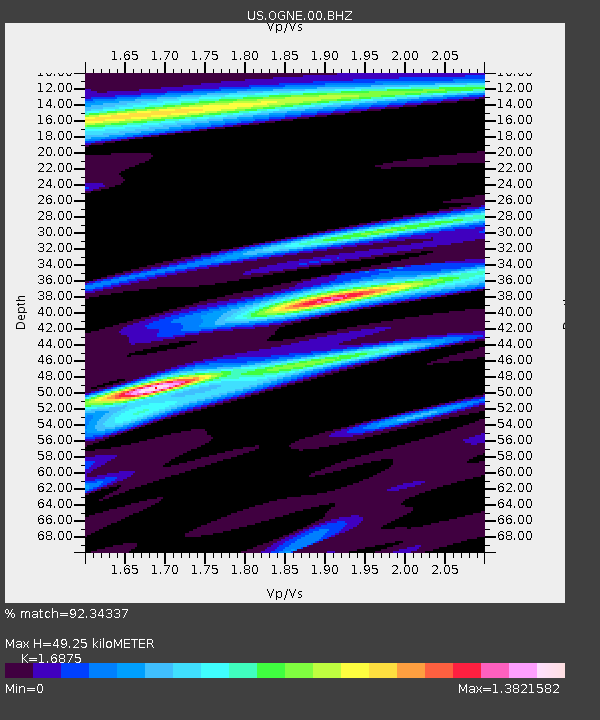
| Estimated Moho Depth: |
49.25 km |
| Estimated Crust Vp/Vs: |
1.69 |
| Assumed Crust Vp: |
6.483 km/s |
| Estimated Crust Vs: |
3.842 km/s |
| Estimated Crust Poisson's Ratio: |
0.23 |
|
| Radial Match: |
92.34337 % |
| Radial Bump: |
326 |
| Transverse Match: |
76.656746 % |
| Transverse Bump: |
400 |
| SOD ConfigId: |
2140511 |
| Insert Time: |
2017-08-03 14:44:33.089 +0000 |
| GWidth: |
2.5 |
| Max Bumps: |
400 |
| Tol: |
0.001 |
|
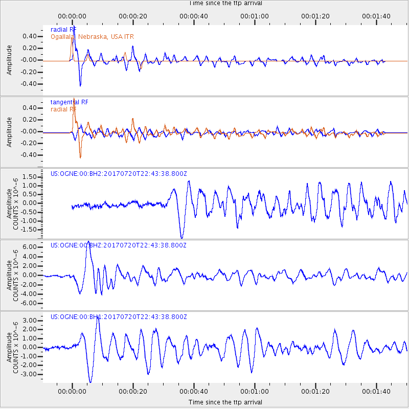
Signal To Noise
| Channel | StoN | STA | LTA |
| US:OGNE:00:BHZ:20170720T22:43:38.800Z | 26.287523 | 2.3464365E-6 | 8.926047E-8 |
| US:OGNE:00:BH1:20170720T22:43:38.800Z | 5.146596 | 8.080692E-7 | 1.5701043E-7 |
| US:OGNE:00:BH2:20170720T22:43:38.800Z | 4.6432405 | 4.6617362E-7 | 1.0039834E-7 |
| Arrivals |
| Ps | 5.3 SECOND |
| PpPs | 20 SECOND |
| PsPs/PpSs | 25 SECOND |


