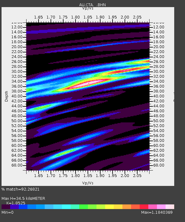
CTA Charters Towers, Queensland - Earthquake Result Viewer

Earthquake location: Talaud Islands, Indonesia
Earthquake latitude/longitude: 3.8/126.6
Earthquake time(UTC): 2009/03/16 (075) 14:15:56 GMT
Earthquake Depth: 35 km
Earthquake Magnitude: 6.2 MB, 6.0 MS, 6.3 MW, 6.3 MW
Earthquake Catalog/Contributor: WHDF/NEIC
Network: AU Australian Seismological Centre
Station: CTA Charters Towers, Queensland
Lat/Lon: 20.09 S/146.25 E
Elevation: 426 m
Distance: 30.6 deg
Az: 141.553 deg
Baz: 318.693 deg
Ray Param: 0.07924744
Estimated Moho Depth: 34.5 km
Estimated Crust Vp/Vs: 1.85
Assumed Crust Vp: 6.522 km/s
Estimated Crust Vs: 3.52 km/s
Estimated Crust Poisson's Ratio: 0.29
Radial Match: 92.26821 %
Radial Bump: 363
Transverse Match: 68.87219 %
Transverse Bump: 400
SOD ConfigId: 2658
Insert Time: 2010-03-08 23:48:27.673 +0000
GWidth: 2.5
Max Bumps: 400
Tol: 0.001

Signal To Noise

ChannelStoNSTALTA
AU:CTA: :BHN:20090316T14:21:37.150002Z3.4557314.597336E-71.3303513E-7
AU:CTA: :BHE:20090316T14:21:37.150002Z2.14701322.3134224E-71.07750736E-7
AU:CTA: :BHZ:20090316T14:21:37.150002Z1.99296822.0982628E-71.05283306E-7
Arrivals
Ps4.9 SECOND
PpPs14 SECOND
PsPs/PpSs19 SECOND