You are here: Home > Network List > N4 - Central and EAstern US Network Stations List
> Station Q51A Peebles, OH, USA > Earthquake Result Viewer
Q51A Peebles, OH, USA - Earthquake Result Viewer
| Earthquake location: |
Alaska Peninsula |
| Earthquake latitude/longitude: |
54.8/-161.3 |
| Earthquake time(UTC): |
2020/08/08 (221) 14:42:55 GMT |
| Earthquake Depth: |
42 km |
| Earthquake Magnitude: |
5.5 mww |
| Earthquake Catalog/Contributor: |
NEIC PDE/us |
|
| Network: |
N4 Central and EAstern US Network |
| Station: |
Q51A Peebles, OH, USA |
| Lat/Lon: |
39.03 N/83.35 W |
| Elevation: |
362 m |
|
| Distance: |
52.7 deg |
| Az: |
73.185 deg |
| Baz: |
314.636 deg |
| Ray Param: |
0.066491805 |
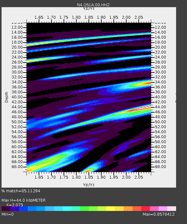
| Estimated Moho Depth: |
44.0 km |
| Estimated Crust Vp/Vs: |
2.08 |
| Assumed Crust Vp: |
6.232 km/s |
| Estimated Crust Vs: |
3.003 km/s |
| Estimated Crust Poisson's Ratio: |
0.35 |
|
| Radial Match: |
85.11294 % |
| Radial Bump: |
400 |
| Transverse Match: |
69.02549 % |
| Transverse Bump: |
400 |
| SOD ConfigId: |
21709731 |
| Insert Time: |
2020-08-22 14:56:56.569 +0000 |
| GWidth: |
2.5 |
| Max Bumps: |
400 |
| Tol: |
0.001 |
|

Signal To Noise
| Channel | StoN | STA | LTA |
| N4:Q51A:00:HHZ:20200808T14:51:35.290011Z | 12.471007 | 5.446123E-7 | 4.3670273E-8 |
| N4:Q51A:00:HH1:20200808T14:51:35.290011Z | 3.9016178 | 2.1127708E-7 | 5.4151148E-8 |
| N4:Q51A:00:HH2:20200808T14:51:35.290011Z | 5.5434127 | 2.3730334E-7 | 4.2808168E-8 |
| Arrivals |
| Ps | 7.9 SECOND |
| PpPs | 21 SECOND |
| PsPs/PpSs | 29 SECOND |


