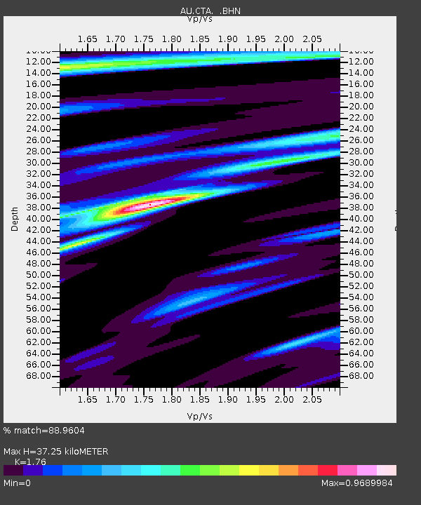
CTA Charters Towers, Queensland - Earthquake Result Viewer

Earthquake location: Talaud Islands, Indonesia
Earthquake latitude/longitude: 3.9/126.4
Earthquake time(UTC): 2009/02/12 (043) 03:49:39 GMT
Earthquake Depth: 26 km
Earthquake Magnitude: 6.0 MB, 5.8 MS, 6.0 MW, 6.0 MW
Earthquake Catalog/Contributor: WHDF/NEIC
Network: AU Australian Seismological Centre
Station: CTA Charters Towers, Queensland
Lat/Lon: 20.09 S/146.25 E
Elevation: 426 m
Distance: 30.8 deg
Az: 141.504 deg
Baz: 318.647 deg
Ray Param: 0.07920878
Estimated Moho Depth: 37.25 km
Estimated Crust Vp/Vs: 1.76
Assumed Crust Vp: 6.522 km/s
Estimated Crust Vs: 3.705 km/s
Estimated Crust Poisson's Ratio: 0.26
Radial Match: 88.9604 %
Radial Bump: 273
Transverse Match: 55.30336 %
Transverse Bump: 400
SOD ConfigId: 2658
Insert Time: 2010-03-08 23:48:40.706 +0000
GWidth: 2.5
Max Bumps: 400
Tol: 0.001

Signal To Noise

ChannelStoNSTALTA
AU:CTA: :BHN:20090212T03:55:22.925015Z6.08331631.1374284E-61.8697506E-7
AU:CTA: :BHE:20090212T03:55:22.925015Z4.87304645.9750636E-71.2261455E-7
AU:CTA: :BHZ:20090212T03:55:22.925015Z4.38498835.9880006E-71.365568E-7
Arrivals
Ps4.7 SECOND
PpPs15 SECOND
PsPs/PpSs19 SECOND