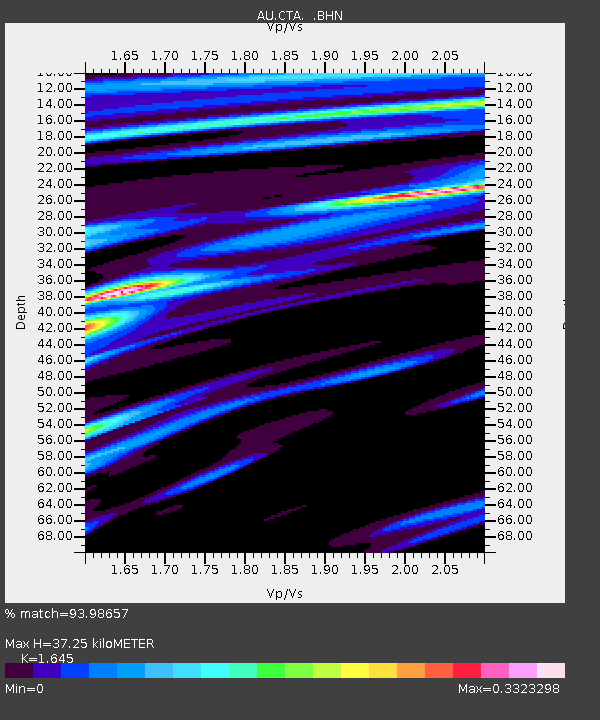
CTA Charters Towers, Queensland - Earthquake Result Viewer

Earthquake location: Kermadec Islands, New Zealand
Earthquake latitude/longitude: -30.7/-178.6
Earthquake time(UTC): 2009/02/17 (048) 03:30:53 GMT
Earthquake Depth: 13 km
Earthquake Magnitude: 5.5 MS, 5.4 MB, 6.0 MW, 6.0 MW
Earthquake Catalog/Contributor: WHDF/NEIC
Network: AU Australian Seismological Centre
Station: CTA Charters Towers, Queensland
Lat/Lon: 20.09 S/146.25 E
Elevation: 426 m
Distance: 33.3 deg
Az: 280.142 deg
Baz: 115.594 deg
Ray Param: 0.07825028
Estimated Moho Depth: 37.25 km
Estimated Crust Vp/Vs: 1.64
Assumed Crust Vp: 6.522 km/s
Estimated Crust Vs: 3.965 km/s
Estimated Crust Poisson's Ratio: 0.21
Radial Match: 93.98657 %
Radial Bump: 218
Transverse Match: 71.93743 %
Transverse Bump: 400
SOD ConfigId: 2658
Insert Time: 2010-03-08 23:48:47.252 +0000
GWidth: 2.5
Max Bumps: 400
Tol: 0.001

Signal To Noise

ChannelStoNSTALTA
AU:CTA: :BHN:20090217T03:37:00.125013Z8.5186639.770854E-71.14699375E-7
AU:CTA: :BHE:20090217T03:37:00.125013Z2.23970842.303575E-71.0285155E-7
AU:CTA: :BHZ:20090217T03:37:00.125013Z3.81586275.6716897E-71.4863453E-7
Arrivals
Ps4.0 SECOND
PpPs14 SECOND
PsPs/PpSs18 SECOND