You are here: Home > Network List > UU - University of Utah Regional Network Stations List
> Station PNSU Preston Nutter Ranch, Sunnyside, UT, USA old TA-P18A > Earthquake Result Viewer
PNSU Preston Nutter Ranch, Sunnyside, UT, USA old TA-P18A - Earthquake Result Viewer
| Earthquake location: |
Dodecanese Islands, Greece |
| Earthquake latitude/longitude: |
36.9/27.5 |
| Earthquake time(UTC): |
2017/07/20 (201) 22:31:12 GMT |
| Earthquake Depth: |
10 km |
| Earthquake Magnitude: |
6.7 Mww |
| Earthquake Catalog/Contributor: |
NEIC PDE/us |
|
| Network: |
UU University of Utah Regional Network |
| Station: |
PNSU Preston Nutter Ranch, Sunnyside, UT, USA old TA-P18A |
| Lat/Lon: |
39.63 N/110.25 W |
| Elevation: |
2743 m |
|
| Distance: |
94.4 deg |
| Az: |
328.581 deg |
| Baz: |
32.734 deg |
| Ray Param: |
0.041042943 |
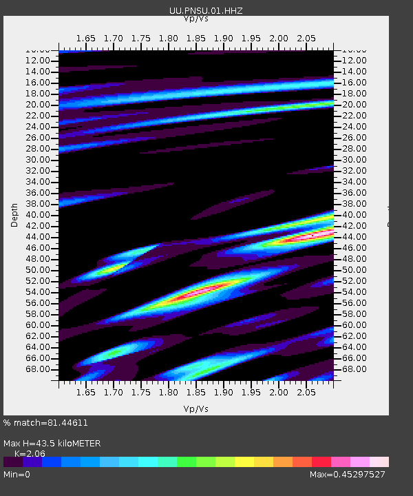
| Estimated Moho Depth: |
43.5 km |
| Estimated Crust Vp/Vs: |
2.06 |
| Assumed Crust Vp: |
6.207 km/s |
| Estimated Crust Vs: |
3.013 km/s |
| Estimated Crust Poisson's Ratio: |
0.35 |
|
| Radial Match: |
81.44611 % |
| Radial Bump: |
400 |
| Transverse Match: |
85.520065 % |
| Transverse Bump: |
368 |
| SOD ConfigId: |
2140511 |
| Insert Time: |
2017-08-03 14:45:57.070 +0000 |
| GWidth: |
2.5 |
| Max Bumps: |
400 |
| Tol: |
0.001 |
|

Signal To Noise
| Channel | StoN | STA | LTA |
| UU:PNSU:01:HHZ:20170720T22:44:00.487988Z | 9.664904 | 3.1838695E-8 | 3.2942589E-9 |
| UU:PNSU:01:HHN:20170720T22:44:00.487988Z | 3.2935288 | 7.572619E-9 | 2.2992417E-9 |
| UU:PNSU:01:HHE:20170720T22:44:00.487988Z | 4.7150884 | 7.314477E-9 | 1.5512915E-9 |
| Arrivals |
| Ps | 7.5 SECOND |
| PpPs | 21 SECOND |
| PsPs/PpSs | 29 SECOND |


