You are here: Home > Network List > US - United States National Seismic Network Stations List
> Station WMOK Wichita Mountains, Oklahoma, USA > Earthquake Result Viewer
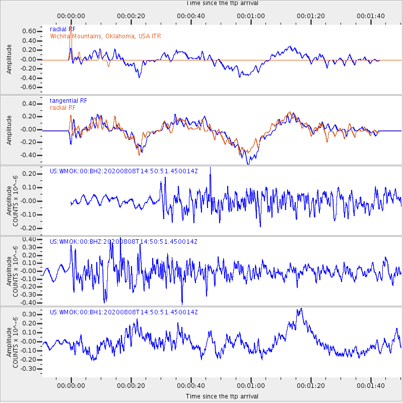
WMOK Wichita Mountains, Oklahoma, USA - Earthquake Result Viewer
*The percent match for this event was below the threshold and hence no stack was calculated.
| Earthquake location: |
Alaska Peninsula |
| Earthquake latitude/longitude: |
54.8/-161.3 |
| Earthquake time(UTC): |
2020/08/08 (221) 14:42:55 GMT |
| Earthquake Depth: |
42 km |
| Earthquake Magnitude: |
5.5 mww |
| Earthquake Catalog/Contributor: |
NEIC PDE/us |
|
| Network: |
US United States National Seismic Network |
| Station: |
WMOK Wichita Mountains, Oklahoma, USA |
| Lat/Lon: |
34.74 N/98.78 W |
| Elevation: |
486 m |
|
| Distance: |
46.9 deg |
| Az: |
88.572 deg |
| Baz: |
315.343 deg |
| Ray Param: |
$rayparam |
*The percent match for this event was below the threshold and hence was not used in the summary stack. |
|
| Radial Match: |
51.045208 % |
| Radial Bump: |
400 |
| Transverse Match: |
44.53444 % |
| Transverse Bump: |
400 |
| SOD ConfigId: |
21709731 |
| Insert Time: |
2020-08-22 15:05:18.115 +0000 |
| GWidth: |
2.5 |
| Max Bumps: |
400 |
| Tol: |
0.001 |
|
Signal To Noise
| Channel | StoN | STA | LTA |
| US:WMOK:00:BHZ:20200808T14:50:51.450014Z | 3.6205127 | 1.459868E-7 | 4.0322135E-8 |
| US:WMOK:00:BH1:20200808T14:50:51.450014Z | 0.9880074 | 6.1155376E-8 | 6.189769E-8 |
| US:WMOK:00:BH2:20200808T14:50:51.450014Z | 2.9318228 | 7.831288E-8 | 2.6711328E-8 |
| Arrivals |
| Ps | |
| PpPs | |
| PsPs/PpSs | |


