You are here: Home > Network List > TX - Texas Seismological Network Stations List
> Station FW14 Alvarado > Earthquake Result Viewer
FW14 Alvarado - Earthquake Result Viewer
| Earthquake location: |
Dodecanese Islands, Greece |
| Earthquake latitude/longitude: |
36.9/27.5 |
| Earthquake time(UTC): |
2017/07/20 (201) 22:31:12 GMT |
| Earthquake Depth: |
10 km |
| Earthquake Magnitude: |
6.7 Mww |
| Earthquake Catalog/Contributor: |
NEIC PDE/us |
|
| Network: |
TX Texas Seismological Network |
| Station: |
FW14 Alvarado |
| Lat/Lon: |
32.40 N/97.19 W |
| Elevation: |
219 m |
|
| Distance: |
93.8 deg |
| Az: |
315.777 deg |
| Baz: |
41.336 deg |
| Ray Param: |
0.041190445 |
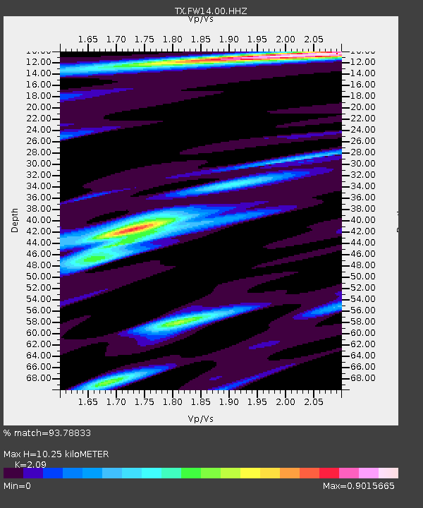
| Estimated Moho Depth: |
10.25 km |
| Estimated Crust Vp/Vs: |
2.09 |
| Assumed Crust Vp: |
6.38 km/s |
| Estimated Crust Vs: |
3.053 km/s |
| Estimated Crust Poisson's Ratio: |
0.35 |
|
| Radial Match: |
93.78833 % |
| Radial Bump: |
299 |
| Transverse Match: |
80.190155 % |
| Transverse Bump: |
365 |
| SOD ConfigId: |
2140511 |
| Insert Time: |
2017-08-03 14:49:51.543 +0000 |
| GWidth: |
2.5 |
| Max Bumps: |
400 |
| Tol: |
0.001 |
|

Signal To Noise
| Channel | StoN | STA | LTA |
| TX:FW14:00:HHZ:20170720T22:43:57.52998Z | 12.25825 | 1.1973024E-6 | 9.767319E-8 |
| TX:FW14:00:HH1:20170720T22:43:57.52998Z | 1.7720327 | 2.4859693E-7 | 1.4028913E-7 |
| TX:FW14:00:HH2:20170720T22:43:57.52998Z | 1.6325448 | 2.3216535E-7 | 1.4221071E-7 |
| Arrivals |
| Ps | 1.8 SECOND |
| PpPs | 4.9 SECOND |
| PsPs/PpSs | 6.7 SECOND |


