You are here: Home > Network List > TX - Texas Seismological Network Stations List
> Station WTFS Witchita Falls > Earthquake Result Viewer
WTFS Witchita Falls - Earthquake Result Viewer
| Earthquake location: |
Dodecanese Islands, Greece |
| Earthquake latitude/longitude: |
36.9/27.5 |
| Earthquake time(UTC): |
2017/07/20 (201) 22:31:12 GMT |
| Earthquake Depth: |
10 km |
| Earthquake Magnitude: |
6.7 Mww |
| Earthquake Catalog/Contributor: |
NEIC PDE/us |
|
| Network: |
TX Texas Seismological Network |
| Station: |
WTFS Witchita Falls |
| Lat/Lon: |
33.77 N/98.46 W |
| Elevation: |
277 m |
|
| Distance: |
93.5 deg |
| Az: |
317.481 deg |
| Baz: |
40.537 deg |
| Ray Param: |
0.041255716 |
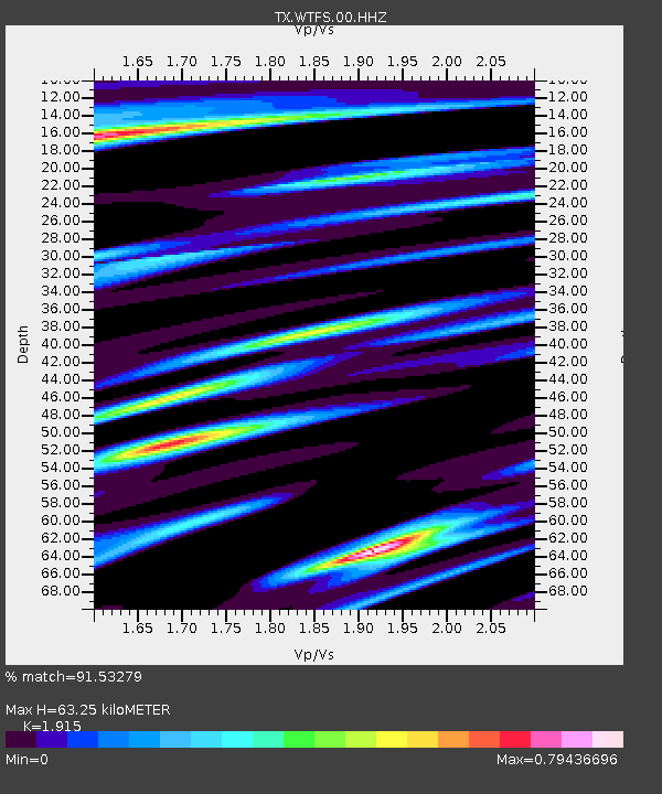
| Estimated Moho Depth: |
63.25 km |
| Estimated Crust Vp/Vs: |
1.91 |
| Assumed Crust Vp: |
6.426 km/s |
| Estimated Crust Vs: |
3.356 km/s |
| Estimated Crust Poisson's Ratio: |
0.31 |
|
| Radial Match: |
91.53279 % |
| Radial Bump: |
285 |
| Transverse Match: |
78.20249 % |
| Transverse Bump: |
400 |
| SOD ConfigId: |
2140511 |
| Insert Time: |
2017-08-03 14:49:59.336 +0000 |
| GWidth: |
2.5 |
| Max Bumps: |
400 |
| Tol: |
0.001 |
|
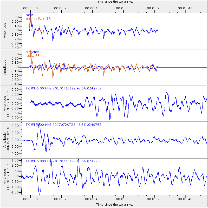
Signal To Noise
| Channel | StoN | STA | LTA |
| TX:WTFS:00:HHZ:20170720T22:43:56.024976Z | 19.109674 | 1.3962663E-6 | 7.3065934E-8 |
| TX:WTFS:00:HH1:20170720T22:43:56.024976Z | 6.792412 | 4.927269E-7 | 7.2540786E-8 |
| TX:WTFS:00:HH2:20170720T22:43:56.024976Z | 1.4939585 | 1.2772622E-7 | 8.549516E-8 |
| Arrivals |
| Ps | 9.2 SECOND |
| PpPs | 28 SECOND |
| PsPs/PpSs | 37 SECOND |


