You are here: Home > Network List > TX - Texas Seismological Network Stations List
> Station SN04 Snyder 4 > Earthquake Result Viewer
SN04 Snyder 4 - Earthquake Result Viewer
| Earthquake location: |
Dodecanese Islands, Greece |
| Earthquake latitude/longitude: |
36.9/27.5 |
| Earthquake time(UTC): |
2017/07/20 (201) 22:31:12 GMT |
| Earthquake Depth: |
10 km |
| Earthquake Magnitude: |
6.7 Mww |
| Earthquake Catalog/Contributor: |
NEIC PDE/us |
|
| Network: |
TX Texas Seismological Network |
| Station: |
SN04 Snyder 4 |
| Lat/Lon: |
32.90 N/100.87 W |
| Elevation: |
716 m |
|
| Distance: |
95.4 deg |
| Az: |
318.476 deg |
| Baz: |
39.144 deg |
| Ray Param: |
0.040787812 |
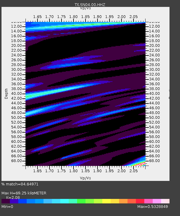
| Estimated Moho Depth: |
69.25 km |
| Estimated Crust Vp/Vs: |
2.08 |
| Assumed Crust Vp: |
6.426 km/s |
| Estimated Crust Vs: |
3.089 km/s |
| Estimated Crust Poisson's Ratio: |
0.35 |
|
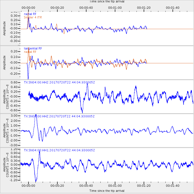
| Radial Match: |
84.64971 % |
| Radial Bump: |
400 |
| Transverse Match: |
82.7109 % |
| Transverse Bump: |
262 |
| SOD ConfigId: |
2140511 |
| Insert Time: |
2017-08-03 14:50:58.688 +0000 |
| GWidth: |
2.5 |
| Max Bumps: |
400 |
| Tol: |
0.001 |
|
Signal To Noise
| Channel | StoN | STA | LTA |
| TX:SN04:00:HHZ:20170720T22:44:04.930005Z | 18.893595 | 1.1065127E-6 | 5.8565497E-8 |
| TX:SN04:00:HH1:20170720T22:44:04.930005Z | 2.9680362 | 3.4879176E-7 | 1.17516E-7 |
| TX:SN04:00:HH2:20170720T22:44:04.930005Z | 1.1712772 | 1.183999E-7 | 1.0108615E-7 |
| Arrivals |
| Ps | 12 SECOND |
| PpPs | 33 SECOND |
| PsPs/PpSs | 44 SECOND |


